Kings Canyon and Sequoia National Parks
California
After counting down for months leading up to this trip, it was finally time to go! I have wanted to get out to California and visit Jill ever since graduation from PT school but it just hadn’t worked out - not enough PTO, not enough time, conflicting schedules, the list goes on and on. But finally the stars aligned - Jill landed an assignment in Visalia, CA close to several national parks, we nailed down a date, and bam - we had our trip in the books! Ever since our first hiking trip together to Zion & Bryce Canyon National Parks during our second year of graduate school, we have wanted to get back out and do another hiking trip together. I’m so glad it worked out, and I can’t wait to tell you all about it!
Shoutout to our best friend Kim, who is working her butt off being an amazing mom to a beautiful little baby girl! We missed you, we love you, and we can’t wait for you to come next time. Xoxoxo
Day 1: Getting to the Park & Redwood Mountain Grove Hike
I got into Fresno late Wednesday night, and after a few beers and games at Tioga-Sequoia Brewing as well as a late-night pit stop at In-N-Out Burger (because how could we not?), Jill and I turned in for the night with a plan for an early morning start to the park. We made it to the park at around 9am, with our first stop being Crystal Springs campground in the Grant Grove area of Kings Canyon to claim a first come, first serve campsite. Between Kings Canyon and Sequoia there are over 14 different campgrounds, but due to significantly higher than average snowfall this year many of them were closed, leaving only a couple of options for us. Luckily we made it to Crystal Springs with plenty of time and had our choice of a lot of great campsites. We ended up choosing #8, a more secluded site along an outside loop of the campground surrounded by tall trees and a meadow. We set up camp and headed to the visitor center to get some advice on trail conditions and to check the weather - in the days leading up to this trip I was checking the weather more than I would like to admit, and unfortunately the forecast wasn’t looking great with a high percentage of rain and possible thunderstorms each day. It wasn’t raining yet, although it was pretty foggy and cloudy, giving the forest a sort of eerie feel. We decided to do a hike close to our campground and opted for the Redwood Mountain Grove which combined the outer rim of the Sugar Bowl and Hart Tree loops, about 10 miles round trip.

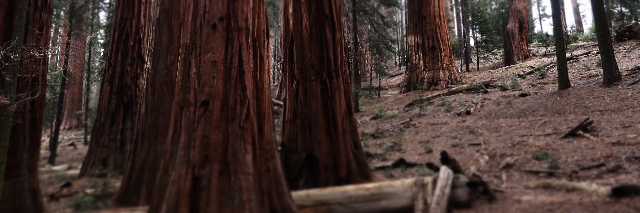
We started on the Hart Tree section, a beautiful trail through dense woods with cedars, firs, dogwoods, and some seriously monstrous sequoias. We practiced identifying the different types of conifers that we saw using a worksheet we got from the visitor center, and might I say we got pretty good at it! Giant Sequoias are the largest trees in the world by volume, with many of the largest sequoias located within Sequoia National Park. They only grow on the western slopes of the Sierra Nevada mountains - the recipe for these beauties includes a lot of moisture, the right temperature (one that doesn’t drop below 0 degrees Fahrenheit too often), and frequent fires. Their bark can be up to 2 feet thick at their base and it is fire-resistant; their pinecones can live for up to 20 years, and their seeds are released with fire. While the fire can damage the tree, it usually doesn’t kill it - we read that sequoias usually only die when they fall over. Back to the Hart Tree Trail - while it was beautiful, it was also extremely hard to follow due to the significant amount of downed trees and flooding which made parts of the trail look like creeks! We probably lost our way 6 or 7 times (conservatively), and luckily each time we made it back to the trail, sometimes taking longer than I would like to admit haha! The trail passed by a small waterfall, went through a downed tree like a tunnel, passed a “log cabin tree” that was built from one fallen sequoia, and took us to a section where we crossed a large creek using a huge downed sequoia as a bridge. We stopped a lot to snap some pictures and just stare up at the huge trees towering over us.

Eventually we made it to the intersection with Sugar Bowl Loop, and this section of trail was much easier to follow. It took us through some more awesome sequoia groves and a ridge that gave us beautiful views of the surrounding mountains. It was still a little hazy but overall was clearing up (and no rain yet - yay!), and the views kept getting better and better the higher we climbed on the ridge. We stopped for a break and had a late lunch staring up at the mountains in front of us. Eventually we made it back to the car, and we both admitted that our first hike of the trip was definitely a doozy, but totally worth it! We went back to the campground and Jill worked very hard to get a fire going, only to have a thunderstorm send us heading to the car for shelter. We waited out the storm in Jill’s car and reflected on our day, what a great first day it was! We also observed one of our campground neighbors doing Tai Chi on a tree stump, in the thunderstorm haha! Eventually the rain stopped, and we started the fire back up again, roasted hotdogs and brats, and stared up at the lightning and listened to the thunder while we sat around the toasty campfire. After a while a second bout of rain sent us into our tent for the night - we welcomed the prompt to get to bed and get some rest!

Day 2: Picking up Lindsey & Cedar Grove Overlook Trail
It rained most of the night on Thursday, and Jill and I woke up Friday morning to no rain but it was very foggy, giving the forest an almost haunted appearance. We had breakfast and went back to the visitor center to get some advice on hikes for the rest of the week. May is part of the shoulder season in Kings Canyon and Sequoia, and visiting during a shoulder season has its pros and cons. On one hand, there were very few visitors (even on the weekend, which I will get to later) which meant we had a lot of privacy when hiking. The mountains were still snowy which makes them even more beautiful in my opinion, and the weather was more temperate (good for me because I’m not a fan of the heat!). On the other hand, there was still a decent amount of snow on the trails especially at higher elevations, so we were limited in which hikes we were able to do. The rangers at the visitor center were really helpful and gave us some good suggestions. At around 11am Jill left to go pick up Lindsey from the airport, and I set off on a solo hike through North Grove Loop and Dead Giant Trail. It ended up being around 4 miles hiking to the trail to and from our campground. It was a nice moderate hike through a grove of mixed forest dotted with giant sequoias, extra cool walking in the mist and light rain with fog creeping through the forest. There were a few neat lookouts between the groves of trees, hard to see anything too far away due to the rain and clouds.

I made it back to the campsite and within 15 minutes Jill and Lindsey were back - what great timing! We packed into the car and headed for the Cedar Grove area of the park - the road out to this area just opened in the weeks before our trip, and the elevation there is much lower making it much more likely that we wouldn’t run into any snow. It was about an hour drive to the trailhead, and we were so happy to see blue sunny skies and jaw-dropping views of the foothills and mountain peaks surrounding the canyon. We stopped at many of the pullouts on the way down to take in the views and the river flowing through the canyon. Another benefit of visiting this park in the spring is that due to the snow melt, the rivers and waterfalls were gushing!

Eventually we made it to our hiking destination for the day - Cedar Grove Overlook trail, 4.6 miles roundtrip with ~ 1200 feet elevation gain. The trail started in a forest down by the river and we slowly but surely climbed up and up, stopping to gush at the beautiful wildflowers including Indian paintbrushes, lupines, and many more that we couldn’t name. We were grateful for the clear day which allowed us to see the beautiful snowy peaks surrounding us throughout this hike. We made our way up steep switchbacks, stopping to rest, take pictures, and goof around. The higher we climbed, the better the views became. The weather was holding steady without any sign of rain or storms, and we were thankful for this stroke of luck! After about an hour and a half we made it to the top of the ridge, thick with burned trees from a forest fire along with 360 degree views of the mountains. We picked a spot on a big rock facing the canyon and had lunch, a summit beer, and relaxed for a while.

Eventually the darker clouds rolling in sent us heading back down to the car. We made great time coming down the ridge, and stopped at Grizzly Falls on our drive back to our campsite in the Grant Grove area. We also made a pitstop on the way back to pose next to a giant yucca which was blooming - it was taller then we were! We made it back to the campsite by around 7, built our fire, and had dinner. The rain had gone, but it left behind an eerie mist - it was really cool sitting around the campfire surrounded by tall trees and fog, again, reminded me of a scary movie! We talked and talked, played games, and celebrated our first day all together. Eventually we settled in for the night - big day of hiking tomorrow!

Day 3: Panoramic Point, Mist Falls, & General Grant
We woke up to sunny skies this morning, the first blue sky we had seen in the Grant Grove area the entire trip! We rushed to get ready so we could take a stab at Panoramic Point, a trail we had previously ruled out due to the less than favorable weather in Grant Grove making it unlikely we would see anything at the top. This is normally only a 0.5 mile hike, however, the road leading up to this point was closed, which added on another 4 miles and over 1,000 feet in elevation (roughly) round-trip. It was a steep hike up the road, all the while I was feeling nervous that it would be for nothing, since things were looking a little foggy off in the distance. The views that we experienced at the top were so worth the climb, and since the road was closed, we had the entire summit to ourselves! We had great views of Hume Lake and tall snowy peaks surrounding a deep canyon.

We relaxed up there for a while taking in the views - it was hard to leave when we had something so special all to ourselves. Eventually we turned around and headed back down the road, back to Jill’s car, and back to the Cedar Grove area for our next destination: Mist Falls. The drive down into the canyon was even more beautiful than the day before - the sky was clearer, the weather was even warmer, and we just couldn’t get enough of those views. We took the road all the way to the end, where we hopped on the Mist Falls trail, 8 miles round trip with ~ 1,000 feet elevation gain. The trail started out in a meadow surrounded by peaks on either side, with the King’s River flowing strongly through the valley. It was pretty flat initially, and we were making good time. We weaved through a mixed conifer forest, the entire time we could hear the river flowing by, and look up to see the peaks. The trail alternated between forest and exposed rocky areas, then we gradually started climbing.

Eventually we made it to an incredible overlook, one of my favorites of the entire trip. We were right in the middle of the valley, with the mountains sloping down on each side and snow-packed peaks towering ahead. We spent a lot of time here relaxing, taking pictures, and just staring at the incredible scenery. We continued along the trail and made it to the waterfall, Mist Falls. Extra full this time of year from all the snowmelt, it really was an amazing sight (and sound). We perched ourselves on a rock near the falls for a bit, but eventually the mist from the falls got to be a little too much and we moved back to our favorite spot on the trail to finish our lunch and relax for a while. It was the perfect place to relax with a large flat area of granite, ideal for lying down and resting. We sat and reflected on our favorite hikes that we’ve ever done. I said Grinnell Glacier, Sky Pond, and Cloud’s Rest; Jill said Mt. Elbert, Conundrum Springs, and Grand Canyon; Linds said The Narrows, Lake Louise, and Emory Peak.

For one of the most popular trails in the entire park we didn’t see many other hikers, especially for a beautiful Saturday afternoon. Most of the time while we were hiking, there wasn’t anyone else around - we saw most of the other people when we were stopped at the lookout. Another benefit of visiting during a less busy time of year! Eventually we headed back down towards the trailhead. We had originally planned to do an additional trail through Zumwalt Meadow, but we ended up driving past the trailhead somehow, and we weren’t too upset about it since we had already hiked over 12 miles and we were exhausted! We stopped at a little outlook to Roaring River Falls before making our way back to Grant Grove. Before heading to the campsite, we stopped by the Grant Tree Trail, a ½ mile loop which took us to the General Grant Tree, the third largest tree in the world by volume, at over 1,700 years old. We went back to our campsite, got a fire going, and roasted some pudgy pies and mashed potatoes. It was another beautiful night, a sky full of stars.

Day 4: Giant Forest & Moro Rock
We woke up to another sunny morning - so much for that weather forecast thankfully! We had some breakfast and packed up camp, stopped at the general store for coffee and second breakfast, and sat out on a patio relaxing before heading out of Grant Grove. We drove down to the Giant Forest section of Sequoia National Park - up until this point we had spent all of our time in Kings Canyon, so we were excited to see how Sequoia NP compared. We hiked to the General Sherman Tree, the largest tree in the world by volume. It is 275 feet tall, and a sign by the tree said that a human looking up at this tree was the equivalent of a mouse looking up at a 6-foot tall person - really puts things into perspective! It was a monster of a tree, really cool because it stayed thick the whole way up! There was a neat mural on the ground close to the tree which showed the outline of its base, which also gave us some perspective on how huge it really was.

We each cracked a General Sherman IPA in honor of the great tree, stared up at it a little longer, than started on the Congress Trail - a 3 mile loop which took us through another giant sequoia grove. We saw tons more giant sequoias, including The President, The Senate Group, and The House Group, to name a few. We continued on the trail and made it back to the General Sherman, then set off for our final destination of the trip: Moro Rock.

Moro Rock is a rocky granite protrusion on the outskirts of the Giant Forest, and it clocks in at 6,725 feet above sea level. During peak season you can drive up the road which makes the hike about half a mile long. During this time of year, however, that road is closed, which added about three miles round trip onto the hike. This actually worked out in our favor, as there weren’t very many other hikers along the trail - having to hike the road up to Moro Rock definitely deterred a lot of people. Their loss! We could imagine how busy this hike would be during peak season on a weekend, and it definitely would have been less enjoyable for us! The trail up to the summit was almost entirely steps carved into the rock, with handrails lining the border most of the time. It was definitely still nerve-wracking, but the amazing views the entire way up made it more than worth it!

On some sections of trail there was only room for one body, so occasionally we had to stop and let people pass, or other hikers stopped to let us pass. After about 350 steps (depends on which source you look at and I was too preoccupied to count!), we made it to the top. It was a long flat summit, lined with guard rails. I don’t know how else to describe the views at the top other than stunning. We had another perfect clear day, and perfect views of the snowy peaks of the surrounding Sierra Mountains. We perched ourselves on the rock up against the railing and stared out at the mountains while we had our lunch. It was sad knowing this was our last hike of the trip, which made it even harder to leave. Eventually we made ourselves start our trek down, stopping frequently on those granite steps to look out at the mountains. We made it back to the car, and headed back toward Visalia, of course stopping at a couple of local breweries on our way. We sat and talked about our favorite hikes of the trip - all three of us agreed that Mist Falls Trail was our favorite, but it was so hard to choose. I loved every hike on this trip, and I was downhearted that the trip was nearing its end.

Now for some reflections. This trip gave me a newfound appreciation for visiting national parks in the off-season. Yes, we were unable to do a lot of the hikes that we originally planned due to snow, specifically hikes at higher elevations…BUT, there were so many lower elevation hikes to choose from that we were able to do and those hikes were absolutely amazing. Another perk was that there were a LOT fewer visitors, we had a lot of trails almost to ourselves, and those trails that did have other hikers had thin crowds. I really don’t think that there is a bad time to visit any national park, there’s always something to do and somewhere to go in these amazing places. It also made me appreciate how amazing my friends are, and how lucky I am to have them in my life! Until next time.
Head over to the gallery here to check out more photos from the trip! I hope you enjoyed reading this post - thanks for stopping by, folks!

I also want to give credit to Jill and Linds for sharing some of their awesome pictures with me - you guys are great!
Sources: https://www.nps.gov/parkhistory/online_books/cook/sec1.htm https://news.nationalgeographic.com/news/2013/08/130826-giant-sequoias-yosemite-rim-fire-forestry-science/ https://www.nps.gov/seki/planyourvisit/sequoiagroves.htm