SHT: Lake County 7 to Silver Bay
Silver Bay, MN
Well we just couldn’t get enough our first time around, so we decided to go back again last weekend for another backpacking trip on the SHT, this time a little farther south on the trail. It is our goal to eventually hike all the sections, all 300+ miles. We realize this will take us a while, but we look forward to the journey and the satisfaction of having completed all of it.
A few things we changed going into this weekend - we ditched a few things from our packs and switched out some gear to make our loads a little lighter, we took off Monday to give ourselves an extra day, and we increased our daily mileage. We have been looking forward to trying this section ever since we got the guidebook for Christmas - it’s described as one of the most difficult and scenic sections on the trail. Our total mileage according to the guidebook was 25.5 miles over 2.5 days, but we have a sneaking suspicion that the book underestimates the mileage. The SHT community has some mixed views on this, but more on that later. Let’s talk about the trail!
Day 1: Lake County 7 to East Kennedy Creek Campsite
We stayed the night at the cabin again on Friday so we could get a little bit more sleep instead of driving all the way up to Silver Bay from Minneapolis in one stretch. It was nice to catch up with the Simons and have a good meal before heading out on the trail for two nights! We parked at the SHT lot in Silver Bay on Saturday morning, hitched a ride on the SHT shuttle up to Lake County 7, and we were off! Our plan was ~12 miles to one of the campsites around Kennedy Creek, and we knew we had a long day ahead. We hiked past the East Branch of the Baptism River, Leskinen Creek Campsite, then over a narrow boardwalk labeled “Ladyslipper Area” - we didn’t see any flowers in this part but the ground was covered with bright moss. The trail continued through the forest, then crossed 400+ feet of boardwalk over a beaver dam at Sawmill Pond. This was a really fun section - the boards were a little unsteady but that made it all the more fun, and it was cool to walk suspended above the beaver dam and pond.

After about 5.5 miles we stopped for a rest at a creek, had some snacks, and resupplied our water. We were feeling pretty good, and in our minds we were almost half done for the day…but the trail had other plans for us. We were using our Apple watches with GPS to track our progress on the trail, but it wouldn’t end up lining up with the mileage in the guidebook (we wouldn’t realize this until mile 12 or 13, haha!) Next the trail started a steep climb up towards the Section 13 cliffs. We hiked a short SHT section as a day hike last year up to these cliffs, and wow they were just as pretty as we remembered. This time we came in from the opposite direction so we got a different perspective. We explored around the cliffs for a while, took a breather, then continued on the trail.

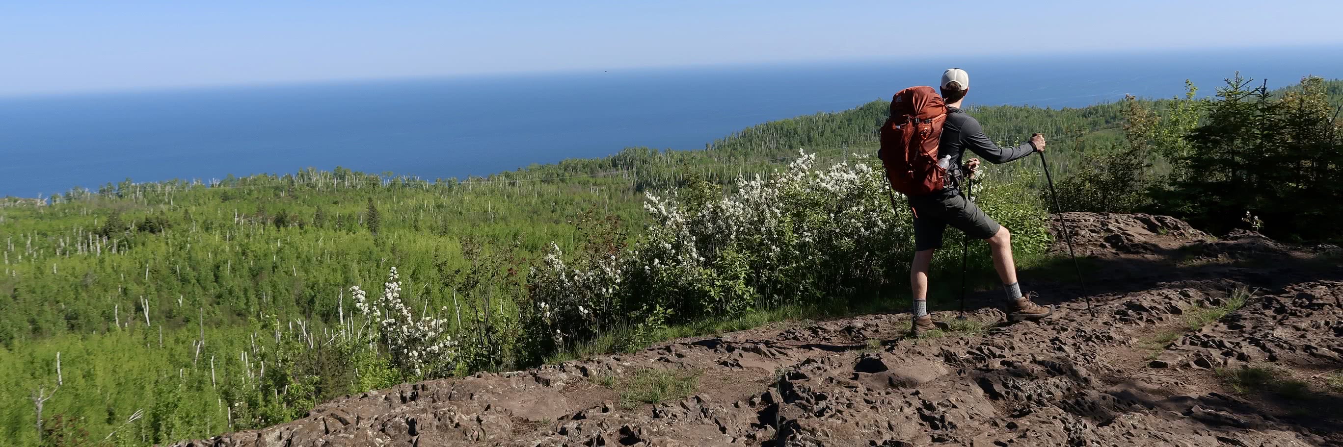
The trail crossed Lake County 6, and we passed a sign that stated we had 4.4 miles to our campsite for the night. We took another short rest break in the shade by the edge of the road - shade had been pretty elusive so far, and it was warmer than we expected (and muggy). We hiked to Picnic Rock, another shady cool spot at the bottom of some tall cliffs, then the trail led us along a ridge with great views of Lake Superior. Next the trail went up to Sawmill Dome, with steep rocky cliffs overlooking Sawmill Creek Valley. We passed by tons more wildflowers on this trip - Northern Bluebell, Purple Clematis, and Red Columbine flowers were new to us this weekend, and we saw more Marsh Marigolds and Juneberries as well. We had never hiked the SHT in June, so the wildflowers were a special treat.

Something that we haven’t mentioned yet is the crazy amount of elevation changes on the SHT, this section in particular. Think of a never-ending rollercoaster…you work your butt off and climb up and up, then the trail descends into a deep gorge or creek bed, then the next thing you know you’re going back up to another overlook, etc. etc. That was probably a bit dramatic (yes this is Ashley writing, shocking that I’m being dramatic I know). Every time the trail starts descending again, we curse ourselves a little bit inside knowing very well that we will need to make it up later down the trail (and we were always right). We have a love-hate relationship with the elevation changes, but hey, the SHT is so beautiful we can’t stay mad for too long :)

It was around this point we started realizing that our GPS distance and the guidebook descriptions weren’t lining up - we were expecting the campsite to be right around the corner, but the trail kept climbing instead of descending down to a creek. The trail brought us up to one more beautiful overlook of the rugged terrain around us including Lake Superior, Mystical Mountain, and Marshall Mountain. We pushed through another mile-ish (who knows how long it actually was), and made it to East Kennedy Creek Campsite by ~5:30, nabbing the last tent pad in a private little section surrounded by thick woods. We were exhausted and hungry, so we made dinner, set up camp, and were lying in our tent by 7:30pm. More hikers showed up after us and ended up having to share another spot, since our area was only enough space for our little two-person tent. West and East Kennedy sites were both full, and we were thankful to be on the East side which was definitely quieter. According to the guidebook, today’s hike was 12 miles. According to our GPS, we hiked 13.3 miles and gained 2,000 feet in elevation. We went to bed for some much needed sleep!

Day 2: East Kennedy Creek Campsite to Bear Lake Campsite
We woke up early Sunday morning, around 6am (that will happen when you go to bed so early haha). We had our breakfast, packed up camp, and we were back on the trail by 7:30. Right away the trail climbed up to a beautiful overlook of Lake Superior, which was really light and glassy so early in the morning. The trail continued to climb a bit and brought us to an overlook of Wolf Lake, a figure-eight shaped lake down in a depression surrounded by tall ridges of pine trees. We moved on and took a spur trail to Fantasia Overlook where we saw awesome views of Lake Superior, Palisade Head, and Mt. Trudee.

The trail crossed State Highway 1, then started getting steep again, climbing up over big boulders which led us to another overlook. We passed by lots more wildflowers, then went through a thick wooded area and a “balsam-fir tunnel” heading into Tettegouche State Park. We took another spur trail down to High Falls, the tallest waterfall that’s located entirely in Minnesota. It was a beautiful waterfall surrounded by tall rocky walls lined with trees, and the mist coming from the falls was really refreshing. We took a break here for a while, filtered more water, and had some snacks. There were only a few other people, and after a little while we had the falls to ourselves.

The trail climbed up a bunch of wooden stairs (which seemed to go on forever haha), then took us to the top of High Falls, and crossed a suspension bridge over the Baptism River. Next the trail went up “The Drainpipe”, which the guide describes as a “150-foot rock crevice with rock steps” - since then they have added some (steep) wooden steps, but it was cool to climb up through the crevice. The trail played rollercoaster again, but eventually climbed up to the top of Mt. Trudee, where we had nice views of Tettegouche Lake and Mic Mac Lake. We stayed at the top for a while for our second long break of the day, had more snacks, rested our legs, and enjoyed the views. The sky was looking a little dark, and there was about a 50% chance of rain for the afternoon. We knew we were still about 3 miles from our campsite, but didn’t know how long it would actually be since we didn’t exactly trust the guidebook at this point haha. The trail continued along the top of Mt. Trudee on a ridge, it started sprinkling a little but that quickly passed.

The trail descended down into the forest, and we passed some more muddy sections. We were both pretty tired at this point, and felt rushed to get to our campsite for the night. Bear Lake is one of the more popular sites along the SHT, and it is full most of the time on the weekends - we purposely planned to stay here on a Sunday night knowing it would improve our chances of getting a spot. Like I said in my last post, it is a requirement to share sites on the SHT…but we knew Bear Lake only had 4 tent pads, and we weren’t really sure what we would do if there wasn’t a place to camp. We skipped the Round Mountain spur in the interest of time, and to try to avoid getting stuck in a downpour which was clearly imminent based on the strong winds and darkening sky. Even without taking the spur, the trail still led us out to some really beautiful overlooks of cliffs, valleys, and the surrounding “mountains”. Next thing we knew we had reached the famous Bean and Bear Overlook - something we have seen in pictures, but had never witnessed ourselves. Two lakes lined up, one in front of the other, surrounded by steep ridges and bright green trees. We wished we could have stayed longer, but with the rain rolling in we wanted to get down to Bear Lake and get set up as soon as possible! We snapped a few pictures and then started our steep trek down to the lakeshore.

It was rugged, rocky, and a tad slippery going down, but we made it, and snagged the last tent pad right on the lakeshore! There was another group of campers there, a father and his daughters from Minneapolis, but their area was tucked away behind some trees and we all had a good amount of privacy. It was about 3:30, and we quickly set up the tent, made first dinner, and had just enough time to eat before the rain rolled in. We hurried into the tent to get out of the rain and relaxed for a while, we even took a much-needed nap! The rain let up around 7, and we made a little bit more food and enjoyed the lovely scenery around camp. After a while the rain came back in - we hung our bear bag, put away the rest of our gear, and crawled back into the tent for the night. I (Ashley) got back up around 9 (Joe was fast asleep haha) and enjoyed a nice sunset over Bear Lake.

Day 3: Bear Lake Campsite to Silver Bay
The next morning the air was fresh from the rain, and most of the humidity was gone (YAY). It was a beautiful day with spotless blue skies. We had breakfast, packed up our wet tent, said goodbye to our campsite neighbors, and left camp around 9am. We climbed up the steep trail away from the lakeshore (which was even more muddy thanks to the rain the night before), then kept climbing until we reached an amazing series of overlooks on a big open ridge, right above Bean Lake. We stayed up there for a while, the views were incredible and the breeze was magnificent! We stopped to chat with another backpacker for a little bit, enjoyed the views, then continued on the trail. We had only 3.4 miles on the docket today, we were relieved to have a shorter day. The trail descended away from Bean Lake, then alternated up and down again - during one of the steep descents I recall mumbling the words “If we go up again I’ll jump off a cliff” (again, maybe a little dramatic haha). We found the mileage for this section to correlate pretty well with the GPS on our watches, and before we knew it we were back at our car at Silver Bay. We topped it off with a traditional stop at Betty’s Pies for a hearty lunch and a piece of s’mores cream pie, which was delicious!

What a weekend! It was long, tough, and definitely pushed us to our limits, but we are really proud of ourselves for tackling such a tough section of trail in a short amount of time. We learned a few lessons…bring more bags for wet gear, bring extra clothes (the same shirt for even 2 days was really not great), and we also need to re-evaluate how many miles we can realistically do in one day, and on consecutive days, without needing to go to bed at 7:30pm haha. We did a little research on the guidebook mileage when we got home, and there were a lot of posts in the SHT Facebook group with hikers describing the same issue we had - it seems like the general consensus is that the guide underestimates the mileage, so plan for a little extra. It was also considerably warmer than we were expecting, and we didn’t bring the best clothing choices for warm weather hiking - we both agreed that we prefer hiking in the fall rather than summertime! We didn’t really have any issues with bugs - we spray all of our clothes with permethrin, and we use picaridin 20% bug spray on our skin. It was a great combination and we didn’t have any ticks, and there were very few mosquitoes bothering us. Overall it was a great trip filled with some of our favorite parts of the SHT. It will be a little while now until we get out there again, but we are looking forward to going back soon!

Check out more pictures from our trip in the gallery.
Sources: Guide to the Superior Hiking Trail, Eighth Edition. Compiled by the Superior Hiking Trail Association.