North Cascades National Park
Washington State
We can’t tell you how excited we were in the months, weeks, days, HOURS leading up to this! We decided almost a year ago that we were going to make North Cascades National Park our next big trip - the mountains, glaciers, turquoise water, and lush green forests pretty much made the decision for us. We chose to make this hiking vacation a little bit of a “glamping” experience, and booked a motel just outside of the park where we planned to stay for the week. We considered driving and car camping, but that idea was quickly thrown out and exchanged for taking a faster and more convenient plane ride to Seattle.
We decided to take the opportunity to spend a little time in Seattle as well. We planned to stay in our motel outside the park in Marblemount, WA and do some day hiking and backpacking in the park for about a week, then stay a night in Seattle and do some exploring around the city! It was a wonderful mix of both wild and urban adventures.
Now for some fun facts! North Cascades National Park was established on October 2, 1968. It is 684,000 acres in size, and forms the part of the North Cascades National Park Service Complex along with Ross Lake Recreation Area and Lake Chelan National Recreation Area (phew that was a mouth full). The Cascade Range runs all the way from British Columbia to northern California, and according to the National Park Service the geology of how these mountains formed is not well-understood. While the tallest peak in the park is a little over 9,000 feet in elevation, the mountains are extra dramatic because they rise from near sea level. The park has over 300 glaciers, more than any other U.S. park outside of Alaska!
After tons of research and the painstaking process where we add and eliminate options for trails, we had a pretty good list of potential hikes we could check off our list - all that came after that was the waiting (which is the hardest part, as the wise Tom Petty once said). Finally the day came, and after a sleepless night our alarms went off and we were on our way to MSP Airport for our flight to Seattle!
We won’t lie this is a pretty long post (lots of hiking to write about!) so use the links below to skip ahead to certain hikes and days if you want! If you’d rather scroll through the whole thing, well, we’re flattered.
Day 1: Getting There and Maple Pass Loop
The trip to the airport and flight were both uneventful, we were able to fly direct from Minneapolis to Seattle. Since we planned to do some backpacking we brought our big packs, and we picked up some extra large duffels from REI to put them in for the flight. Let me tell you, they really held up and protected our packs perfectly. We grabbed our luggage from baggage claim, picked up our rental car (a Subaru Outback, which Ashley was pumped about), and hit the road toward the park. It was pretty foggy and overcast but as we got closer we could start to see the faint outlines of mountains, then they became more and more clear as we drove into the park. Since North Cascades National Park is so close to several recreational areas and national forests, we opted to buy the annual interagency pass which would cover our bases for this trip and many trips to come in the next year. We made our way to the eastern slopes in hopes of better weather and views, and stopped at Diablo Lake Overlook on our way - it was a great introduction to this beautiful park, with bright turquoise water framed by tall peaks on all sides. It seemed like it had to be fake, that’s how gorgeous it was. After looking around the overlook for a while we pulled ourselves away and continued our drive to the trailhead.

We started our hike around 1:45 PM, our first trail of the trip: Maple Pass Loop. We decided to take the loop counterclockwise, we read this would make the views more dramatic and the steepest part would be downhill. The trail started in a forest with a slow but steady incline, every once in a while opening up to nice views of the surrounding mountains. We were really excited that this end of the park seemed to have clear skies. The trail continued to ascend, crossing through some open meadow areas, then an open ridge with some beautiful vistas. We hiked back into the forest and then took a spur trail to Lake Ann - a pretty lake surrounded by peaks which reminded us a lot of a hike we did in Rocky Mountain National Park.

We got back on the main trail and from there it really started to climb up steep switchbacks, out on an open ridge so we had great views the whole time. We watched Lake Ann get smaller and smaller, and the closer we got to Heather Pass the better the views became! Finally we made it up to Heather Pass and got our first look at the other side of the pass. The view from here was just stunning, with tall, pointy peaks on all sides descending sharply toward the valley. There was no rain yet, but it did look a little dark in the distance and we heard thunder a couple of times. So we kept moving, the trail still climbing up toward Maple Pass. This was our favorite part - it was like we were standing in the middle of a bowl, with huge peaks rising up on all sides, surrounding us. The views were constant, and they made the gruelling climb worth every single step. We passed a perfect overlook of Lake Anne, and we could see the trail behind us and how far we’d come.

We kept hiking up the steep trail, then finally made it to Maple Pass. At one point the trail was pretty narrow, with drop-offs on either side and astounding 360-degree views. We were so happy that the skies were mostly clear and we were able to see the amazing scenery around us. The skies were getting darker off to the distance, obscuring the very top of a monstrous white-capped mountain. We heard a little more thunder and worried about the possibility of a downpour, continued on the trail. We hiked out on the open ridge a little longer, taking in the last of the views, then descended down the steep switchbacks toward the trailhead. We passed an overlook of Rainy Lake, then continued down the rugged trail, filled with rocks and roots which made it a little tough especially on tired legs.

After 7.8 miles and about 2,000 feet elevation gain roundtrip, we were finished! This was a great first hike to get us really excited about the North Cascades. It had all the traits of a perfect trail - it was a loop so we never crossed over the same ground twice, it had alpine lakes, and much of the trail was out on exposed ridges which gave us almost continuous views! And no rain while we were hiking, which was a huge plus. We realized when we finished that we never stopped to sit down and relax…we were too excited about walking around and taking in the views, and we were worried about rain - our legs were definitely feeling it! An amazing first day under our belts, we checked into the motel, got some dinner, and hit the hay for some well-deserved sleep.

Day 2: Rainy Forest Hike Along Thunder Creek
We slept in on Sunday morning, relaxed for a while, then got breakfast at a local restaurant close to the hotel. The weather was looking pretty rainy for today, so we stopped by the visitor center for some advice on a hike - our list of hikes that we had planned were mostly summits and viewpoints, and we knew that on a rainy, foggy day we weren’t likely to see very much. We decided on Thunder Creek Trail, an out and back hike where we could decide how long we wanted to hike in the rain. To be honest we weren’t expecting too much from this hike, there was a thick fog in the air and when we started hiking it was misting steadily. It turned out to be an awesome walk through a beautiful forest, and the overcast skies and rain really brought out the vibrant colors of the vegetation and creek.

The pine-needle covered trail weaved through an old growth forest with big cedar trees and a mossy forest floor. It made us feel like we were walking through a rainforest, the rain gently misting down on us as we admired the bright green trees. The best part was that the majority of the trail followed alongside Thunder Creek, filled with beautiful greenish-blue water that reminded us of Gatorade. The trail was well-maintained with a little bit of elevation and occasionally rooty and rocky, but overall it was an easier hike which was nice, our tired legs needed a little TLC after our first day.

The trail crossed a bridge over the creek, and we admired the views up and down stream. It was foggy and misty, but we could sort of see the outline of a mountain upstream. We continued along the trail for a while longer, and turned back after about 2.5 miles. The weather wasn’t improving and we didn’t want to stretch the trail too far - big hiking plans the rest of the week, and it was getting a little chilly in the rain. We stopped back at the motel to change, then went to Glacier Peak Winery (conveniently only a couple of miles from our motel) and did some tasting - they had some really good wines, and we bought a couple of bottles to take home with us. Next we moved on to Birdseye Brewing and listened to some live blues/country music while we had a couple cold ones. They had a great beer selection and the music was great! We finished the night off with some dinner and relaxation.

Day 3: Cutthroat Pass
We decided that even though Monday forecasted rain, it seemed that the rain wouldn’t roll in until later in the afternoon. We headed over to the east slopes again, where overall the weather seemed to be better than the foggy west side. We left the motel early, on the road a little after 5am, to get to Cutthroat Pass and attempt to get up there before the rain started. We made it to the trailhead after about an hour and a half, and after almost starting at the wrong place (facepalm), we got started. The trail began as a relatively flat, sandy path through a forest with mountain peaks poking up above the trees. We could see fog on the horizon slowly creeping over the mountain tops, but overall things looked pretty clear. We took a spur to Cutthroat Lake, then decided to go for it and try hiking up to the pass.

We started up some switchbacks, a nice gentle grade, and despite some fog and overcast skies we had some good views on our hike up - there were even a few spots of blue sky! We stopped for a snack at what looked to be a campsite, with an old fire ring and a nice bench. We took in the views while we had a snack, then got back on the trail. Eventually the switchbacks took us above the treeline, through an alpine meadow with large boulders and great views of Cutthroat Lake and the surrounding mountains.

Finally we made it to Cutthroat Pass, and we were really happy with our views. The beautiful brownish-orange mountains were speckled with the dark green of pine trees, and the dark colors really stood out against the almost white sky. There was some fog obscuring a few of the peaks but for the most part the view was clear, and no rain! We climbed higher on the pass to an overlook and were engulfed in mist and thick fog. The opposite side of the pass was a complete white-out. The trail intersected with the Pacific Crest Trail so we decided to hike a little bit farther, away from the fog, and see what the views were like a mile or so down the trail.

It was pretty level from here, and the trail crossed through boulder fields where we saw and heard lots of pikas! Pikas like it cold, and are most commonly found in higher elevations. They’re adorable, and make the cutest sound ever - “Meep! Meep!” They blend in with the grayish rocks, so sometimes they were hard to spot but we followed the sound of their calls and watched them scurry around. We crossed paths with some other hikers and trail runners (all we could think was: how?), then decided to turn around. We hiked about 6.5 miles already, and we were only halfway done. The skies were still pretty clear, giving us some very beautiful views of the tall mountains with their smooth, sloping sides and narrow peaks. It was a long hike back to the bottom, for a grand total of about 13 miles.

We were really pleased with this hike! Cutthroat Pass wasn’t on our original list of options, but wow we would have missed out if we overlooked this one. It was such a nice trail along an open ridgeline, and even though there was fog on the western side of the pass, we had great views on the eastern side and it was a beautiful area. After we finished our hike we stopped by the Washington Pass Overlook, swung through the Marblemount Ranger Station to pick up our backpacking permit for the following day, and rewarded ourselves with drinks and dinner in town. We went back to the hotel and rested up for our big day!

Day 4: Sahale Glacier Camp, Part 1
The majority of the hikes we did on this trip were planned to be day hikes, but we also wanted to get out into the backcountry and try a little backpacking in a national park. Then we learned about Sahale Glacier Camp - a backpacking campground perched at 7,600 feet, nestled among a sea of mountain peaks. Reservations for this site are taken on a lottery basis only, and we read it was one of the more competitive campsites in the park. We submitted a lottery request back in March, patiently waited for months, and then found out WE GOT IT. We were ecstatic to have this opportunity and savored every minute! We woke up early, stopped for a hearty breakfast at a local restaurant, picked up some fuel for our camp stove, and then made our way up the pothole-infested road to the trailhead. We were thankful to have a 4x4 vehicle! It was foggy and rainy, but every so often we had great views of mountains, waterfalls, and a deep valley, and we weren’t even at the trailhead yet! Eventually we made it, and we put on our rain gear and packs and got on the trail. We hiked up switchbacks through the rainy forest for the first couple of miles, and every once in a while the trail opened up and we could see more waterfalls, glaciers, and mountains with fog obscuring the deep valley.

We came to an open area on a big ridge and the trail crossed a few rockslide areas, where we saw our first marmots of the trip! They didn’t pay too much attention to us. We saw lots more pikas, and gradually the views started to open up a little bit more, revealing the surrounding mountains with their steep slopes engulfed in fog before they reached the valley. It was a very moody scene with the overcast sky, and the mountains seemed to be wrapped up in the fog. The trail leveled out a bit after that, and we finally reached Cascade Pass. This side of the pass was gorgeous, and mostly clear actually. We had nice views of a wide valley with mountains rising up on both sides, and the sun even came out for a while! We took a break here, the rain had gone, and had some snacks while we admired the view. We were joined by another group who was also heading up to Sahale.

We continued on the trail, much steeper now, over switchbacks that gave us great views from above Cascade Pass - one side a complete whiteout, and the other side bright and open. The trail was rocky and the footing was tough in some spots, but the views kept getting better and better the higher we climbed - the dark mountainside spotted with bursts of green (trees) and white (snow/glaciers) was so picturesque and we found ourselves stopping not only to catch our breath, but to stare out at this beautiful landscape. The trail finally flattened out (yay!) and took us through a section of meadows with more breathtaking views - cragged peaks with a deep valley, and Doubtful Lake right in the middle. We enjoyed this area for a while, stopping frequently to take pictures and explore around the meadows, taking care to stay on the marked trail. We were so happy that it was mostly clear and we had such nice views of the valley.

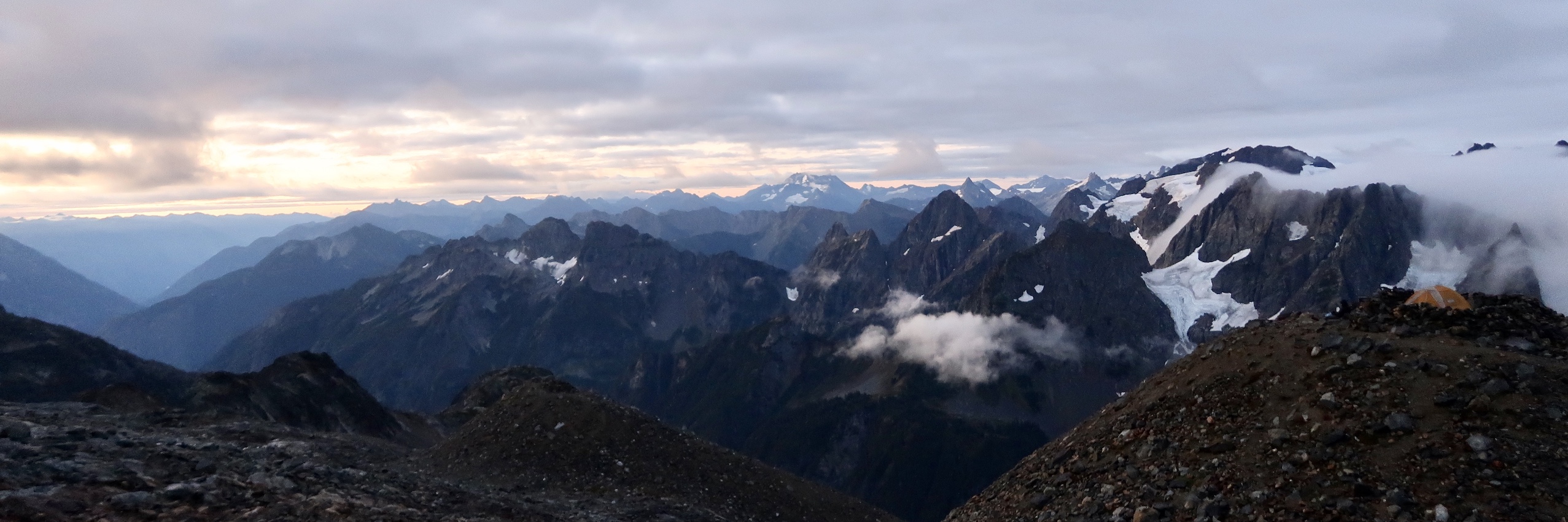
We looked ahead on the trail and saw a higher area covered in thick fog, with rocky terrain and dark skies. We had a feeling that was where we were headed, since we knew we still had a couple thousand feet of elevation to go (at this point according to our watches, we were only half way up - 2,500 feet gained so far…yikes). We saw two more marmots, and looked around for mountain goats but no such luck. After the nice meadow, the trail became extremely difficult - VERY steep grade over a rocky trail, and we had to do some route-finding through a boulder field using cairns to mark the way. It was exhausting and also a little scary hiking through such a steep area with unsure footing, not to mention the 30-pound packs on our backs! At this point we put our rain gear back on, and we were right in the middle of the thick fog, a steady mist with tiny pieces of hail sprinkling down on us. As we got closer, we could see what we thought could be the tent pads at camp, with tall rocky walls surrounding the designated tent areas. Eventually we made it, and we were greeted by a sign - Sahale Glacier Camp.

Even through the thick fog and rain, camp was INCREDIBLE. The giant Sahale Glacier rose up in front of us, hugging the side of the mountain framing the camp. There were lots of tent pads to choose from, there was only one other camper up there so far. All the tent pads were pretty spaced out, and they were all at different elevations which was really unique. We could see where other tent pads were by looking for the tall rocky walls surrounding each one. We heard the trickle of streams formed by the glacial melt flowing through camp, and the rain had let up. The skies were still pretty foggy, but it was moving fast and every so often the views cleared up a little bit and we caught intermittent views of the surrounding mountains and Doubtful Lake far below. We quickly set up the tent while the rain had stopped, cheersed ourselves with a well-earned beer, and had a late lunch. It was around 3pm - the fog and rain rolled back in and the temperature cooled down, so we retired to the tent for a quick nap.

The rain stopped after an hour or so, and we took the opportunity to explore around camp. We admired the view from our tent - it had really opened up while we were resting and we could see a lot more. Incredible views of tall, skinny, pointy mountains dotted with glaciers and snow surrounded us. There was still a lot of fog off to the west, but our views straight ahead and eastward were so beautiful. We grabbed our poles and hiked around camp, so much easier without 30-pound packs on our backs! The terrain of camp was so unique, mainly consisting of large and small rocks, overall sloping down toward the valley, large domes of rocks spaced out with tent pads on top. There were piles of snow everywhere, and although we saw lots of mountain goat poop, no goats for us today! The glacier was a short walk from camp, and we carefully traversed the rocky terrain and got up close and personal with Sahale Glacier!

We walked right up to the glacier and took a few careful steps onto it. We hiked around the side to get closer to some of the crevasses, which were amazing - about as wide as both of us put together shoulder to shoulder, very deep, and this was where we could really see the blue tint of the glacier. This is something we learned on a previous trip: you can tell the difference between a glacier and just plain snow because the glacial ice has a blue tint to it. There were also small rocks ingrained into the glacier, evidence that it was still hard at work. The skies cleared up a little more, and we were lucky enough to see a double rainbow.

We looked back toward our tent pad, and the skies cleared up even a bit more for an absolutely epic backdrop. We scrambled back to our tent over the uneven terrain, filtered some glacial water (so cold, so good!), and started making dinner. The menu was freeze-dried fajita bowls with a freeze-dried raspberry crumble for dessert. Both were delicious, and we sat on the other side of the rocky wall surrounding our tent and enjoyed the last of our great views before a thick fog rolled in. It got pretty cold and windy at this point - we were dressed in multiple layers with winter hat and gloves! We hid the bear canister away from camp and huddled inside the tent, ready for some much-needed rest! A little over 6 miles and 5,000 feet of elevation gained - you bet we were tired!

Day 5: Sahale Glacier Camp, Part 2
We didn’t sleep the best - tossing and turning a lot, a tad bit cold, and we were horrified to see mice crawling around the outside of our tent! Ew! Luckily it wasn’t really that windy, though, and no mice made it into the tent. We woke up and at first we couldn’t tell if it was day or night - the moon had been so bright overnight. We got out of the tent and were so happy to see mostly clear skies, and the beginning of a sunrise! We grabbed our bear canister, laid out our tarp where we had eaten dinner the night before, and started boiling water for some coffee. It was pretty cozy - the rock wall sheltered us from most of the wind, we were all bundled up, and we had a front and center view. We drank our coffee and ate our dehydrated breakfast hash while we watched a beautiful sunrise, the horizon mostly clear except for off to the west by Cascade Pass. We had our best views of the massive, jagged peaks of the North Cascades - layers and layers of them, capped with snow and glaciers. I don’t think any amount of pictures or anything we write in this blog could ever fully capture what it was like to be up there.

We made another cup of coffee and watched the sun come up. Eventually the cold got the better of us and we started packing up camp. More fog started rolling in at that point too, almost like the mountains were telling us it was okay for us to go - because with those views it would have been near impossible to leave. We snapped a few last pictures, used the rustic toilet (best view from a toilet I have ever seen, haha - Ashley), and then we headed down the steep slope.

Scrambling down was much easier than going up…for some reason the fear of falling face first down the mountain wasn’t as crippling as the fear of going down backwards. Hah. We descended through the thick fog, stopped at a waterfall to filter some more water, and then made it back to the meadow area from the day before. It was much foggier on our way down, and we were happy we had such clear views on our ascent the day before. We passed by lots of other people from Minnesota, some fellow Packer fans (go Pack go), and stopped at Cascade Pass for a rest on our way back down. We saw a lot more pikas and marmots, and some other type of animal that looked like a giant marmot except it was black - we suspect it was a different type of marmot than we were used to seeing? No idea. The pass was much clearer on our way down and we were happy to have these views. The switchbacks on our way down seemed to go on forever, but finally we made it back to the car after about 3 ½ hours.

We went back to the motel, hung all our wet gear out to dry, then relaxed in bed while we looked through every single picture we had taken of our hike to and from Sahale. We couldn’t believe it was over - we had been looking forward to this since spring, and it definitely lived up to the hype! We went back to Glacier Peak Winery, and each had a glass while we sat outside in the vineyard with nice views of mountains rising in the distance. It was a nice, sunny day, and we took our time finishing our wine while we planned out the rest of our trip. We treated ourselves to a big dinner, then called it an early night.

Day 6: Hidden Lake Overlook
After hiking Sahale, we didn’t think any other hike would even come close to the epic views we had - we were wrong. It was a clear, perfect day for a hike, and we set our sights on Hidden Lake Overlook - a 9 mile, 3,000 ft elevation gain out-and-back hike. We almost missed the turn off for the road to this trailhead…probably because the road didn’t even look like a road, more like a trail itself with uneven gravel and potholes the size of a grown man! If we thought the road to get to Sahale’s trailhead was bad, this road put it to shame. It was an extremely nerve-wracking drive, very steep with huge gouges in the road, and the Subaru almost got stuck! We made it in one piece, and after some cleansing breaths, we got started on the trail. We like to think this hike had four main zones: forest, open field with tall green brush, subalpine area with some lingering pines and rocky terrain, and last but not least the area above the treeline. We started with a moderate incline through a forest, crossed lots of streams, and hiked up switchbacks that gave us our first mountain views.

Next came the open field area, and it got HOT and STEEP. We climbed higher and higher, the grade not giving us any breaks, but we were thrilled to have the clearest skies we had seen so far on the trip. We continued to ascend and crossed up into the subalpine area, and wow were the views amazing - mountains as far as the eye could see. It was almost like looking out into an ocean, except instead of waves there were mountain peaks. We had great views of the monster, Mt. Baker, bright white and so tall the top was covered by clouds. The trail continued to climb with a more gentle grade. We weren’t even paying attention to the difficulty of the trail at this point, we were too preoccupied with the incredible views all around us!

Next thing we knew we were hiking above the treeline, and we put our poles away as the trail required a little bit of scrambling over boulders from here. We made it to the overlook of Hidden Lake, a beautiful blue lake surrounded by gray, rocky terrain, and tall pointy mountains. We stopped for a rest, put on another layer (it was windy up there!), and looked up to see our final destination of the hike - the lookout shelter, another 300 vertical feet of scrambling away. We took our time, and were amazed that a very good boy (a dog) was kicking our butts with the rock scramble! We made it up to the very top, and were rewarded with 360-degree panoramic views of the mountains around us.

An angry, wild ocean came to mind again - pointy peaks rising up as far as the eye could see, almost completely clear with the exception of a few lingering clouds off in the distance. While the peaks sometimes seemed to all blend together, looking closely we could see each one was unique - some were capped with glaciers and snow, others covered in dark rock, and each one had a distinct shape. We could see Mt. Baker, another giant (not sure what it’s name was), and it was clear enough that we could see Mt. Rainier off in the distance! It was a perfect, blue-sky day and we sat on a nice flat rock and ate our lunch. It was windy, and a little cold, but the views were so amazing we didn’t even care. Another neat thing about this hike is that at the top, there is an old lookout converted to a shelter where you could stay the night! We didn’t go inside because other hikers were resting, but apparently it’s a first come first serve situation and another hiker told us that in the past they have crammed up to 15 people in there!

After we finished eating lunch we put our packs back on and explored around the summit a little more. This required more scrambling over large boulders, and we maneuvered around all sides to take in as many views as we could. We kept saying we couldn’t believe how clear it was, and we were so happy we took a chance on doing this hike because we both agreed it was one of our favorites, ever.

Day 7: Blue Lake
We slept in on Friday morning, which felt amazing after a long week of hiking - our legs thanked us for the break. It was a rainy and gloomy day, and we took our time getting up, had some leftovers for breakfast, and watched the local news. We planned to try Blue Lake, a 5-ish mile out and back hike. We drove to the trailhead, put on our rain gear, and hiked through the rainy forest up and over rocks and roots. It was a nice relaxing hike, alternating gentle ascents with flat areas and the occasional boardwalk. We made it to the lake, and understood how it got its name! It had beautiful deep blue water bordered by pine trees, and we could see the bottoms of the mountains surrounding the lake but the fog obscured most of this view. It was still raining, and we had a quick snack then decided to head back to the car - it was cold!

We stopped in town for soup and sandwiches, then went back to Birdsview Brewing where we enjoyed cold beer, hot food, and some more awesome live music. We went back to our motel, packed up, and relaxed. We called it an early night, reflected on our trip, and pouted that our vacation was coming to an end!

Day 8: Exploring Seattle
We checked out of the motel around 7, and made it to Seattle by 9:30 (after circling the block a few times finding the parking garage, haha). We had reservations at Green Tortoise Hostel, located right next to Pike Place Market! We left the car in a nearby garage and explored the city. Sidebar: you could probably argue that we’re maybe a little too old to stay in a hostel, but hey, it was an awesome deal and great location. Can’t beat it! The first thing we did was check out the market - we watched as they tossed fish back and forth, and sampled lots of fresh fruits and other goodies, including chocolate pasta…yes this was real, no we didn’t buy any (too weird, haha). We had brunch at Athenian, a restaurant in the market, and enjoyed nice views of the harbor from the window in our booth.

We took the ferry over to Bainbridge Island, where we explored the brewery, shops, and wineries in the quaint downtown area, which reminded us a lot of Door County. After a few hours of exploring we took the ferry back to Seattle, walked around the market and surrounding shops again, and had dinner at Chan, a Korean fusion restaurant. We stopped for a nightcap at Sonya’s bar, then went back to the hostel and got ready for bed, and our early flight out of Seattle the next day.

What an incredible trip! As always, it went by way too fast. The North Cascades were as beautiful as we imagined and even though we didn’t have perfect weather, the cloudiness and fog definitely added to the ambiance and moodiness of the mountains and forests. There were two other hikes we originally planned to do, but we opted out due to the weather, tired legs, and/or distance from our motel: Sourdough Mountain and High Pass. If you’re ever in the area we would recommend researching these hikes as well as the other amazing hikes we were able to do! It was really hard for us to pick a favorite hike from this trip, but we both agreed that the hike to Sahale Glacier Camp stood out among the rest, and was one of the most unbelievable hikes we have ever done.
It isn’t a place you take yourself - it’s where that place takes you. We can’t think of a more appropriate quote to summarize being in the presence of amazing places like the North Cascades.
We hope you enjoyed reading about our trip to the North Cascades, thanks for stopping by! Take a look at the rest of our pictures (and a few videos!) in our gallery.

Sources: https://www.nationalgeographic.com/travel/national-parks/north-cascades-national-park/