SHT: Sugar Loaf Road to Crosby-Manitou State Park
Finland, MN
Our first backpacking trip on the Superior Hiking Trail! We’ve been looking forward to getting out and doing this for a long time, ever since our first camping trip to the north shore almost two years ago. We’ve done lots of day hikes along the north shore through state parks and even some sections of the SHT, but we’ve never spent the night out there, or carried all of our camping supplies on our backs for that matter! After we had the gear, the guidebook, and more experience hiking in that area, we were more ready than ever to get out there. For our first overnight section hike we chose an ~11.5 mile stretch (including spurs) over 2 days, starting at Sugar Loaf Road and hiking southbound to Crosby-Manitou State Park. We wanted to keep our daily mileage low since it was our first backpacking trip (ever), and we weren’t sure how well we would do carrying more weight and with the muddy trail conditions due to all the rain and snow this spring.
Now for a little more information on the Superior Hiking Trail, aka the SHT. It is 326 miles long including all of its spur trails, with 310 miles of SHT main trail (depending on which source you go by, it ranges from 306-310 miles of main trail, 324-326 miles including spur trails). It starts at the MN/WI border south of Duluth and ends just shy of the Canadian border, passing by countless rivers, cliffs, the Sawtooth Mountains, inland lakes, dense forests, waterfalls, and of course Lake Superior. The elevation of the trail ranges from 602 feet along Lake Superior to up to 1,820 feet above sea level. There are so many opportunities for hiking along the SHT, both for day hikes and longer backpacking routes, with 94 backcountry sites along the length of the trail. The trail passes through lots of state parks along the north shore including Jay Cooke, Gooseberry Falls, Tettegouche, Crosby-Manitou, Temperance River, Cascade River, and Judge Magney.
One feature (out of many) that we love about hiking along the SHT is that even if you can’t see the lake from the trail, you know it’s never too far away, and we love the anticipation of waiting for the next overlook. Measured by surface area, Lake Superior is the largest freshwater lake in the world - 350 miles long, 160 miles wide, and 1,333 feet deep at its deepest point. The Ojibwa named the lake Gitchi Gami, meaning “big water” - rightfully named!
Day 1: Sugar Loaf Road to Horseshoe Ridge Campsite
We spent the night at the cabin on Friday so we wouldn’t have as far to drive in the morning, since we had to be waiting for the SHT shuttle in the parking lot at 9:07am sharp! Taking the shuttle really came in handy for us - we were able to cover twice as much ground, instead of having to hike only part of the trail out and back or take two cars all the way up to the north shore. This way, we could leave our car at our ending point, and take the shuttle to the start of our hike.
We ended up getting a little bit of a late start Saturday morning, and it took a little longer than we planned to get to Finland, but it all worked out in the end and we made it to the pick-up point at Crosby-Manitou State Park with 5 minutes to spare! The shuttle dropped us off at Sugar Loaf Road to start our hike, and the drive there was beautiful with lots of rolling hills, lakes, and budding trees. It was a beautiful sunny day, mid-60’s, perfect for hiking. We strapped our packs to our backs and set off on the trail!

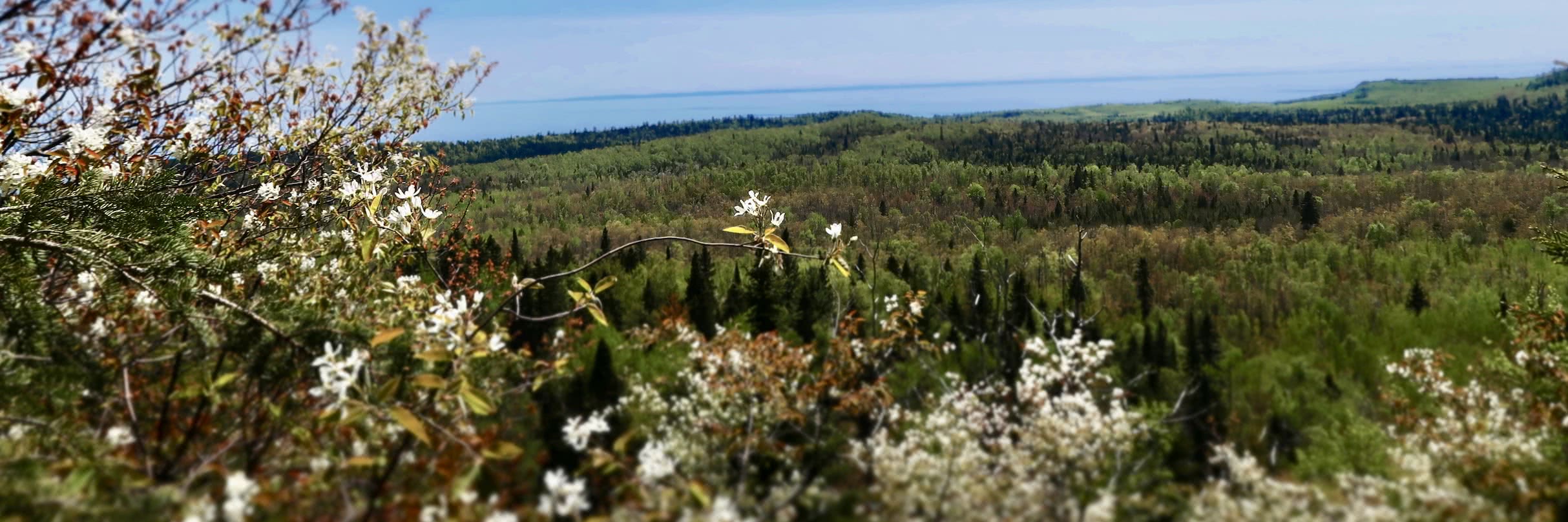
One of the first things we noticed on our drive up, and throughout the trail, was the bright green color of the newly budding trees, and how they contrasted with the dark greens of the conifers. I’m sure that the pictures look like they are extra enhanced to make the greens stand out, but I promise, they’re not! We had never been up to the north shore this early in the season, so this was extra special to us to see the beautiful bright greens. The trail started out in thick woods, mainly flat, which we were thankful for! We passed by lots of day hikers (and dogs!), saw a deer run in front of us on the trail, and passed by a lot of scat, which we would later find out was wolf scat! The trail played peek-a-boo with the lake giving us little glimpses through the trees, until it opened up and gave us our first real look at the lake. It was a little hazy, we think from the wildfires in Canada, but we still had great views of the water and far off Wisconsin on the other side.

The trail crossed over Crystal Creek, and we took a side trail to check out the Crystal Creek Campsite. All of the sites along the SHT need to be shared if there are multiple groups needing/wanting to stay at one site. There was no one at Crystal Creek when we stopped, but it looked like a nice campsite, albeit a little short on shade cover. We continued on the mostly flat trail, and enjoyed more glimpses at Lake Superior through the trees and open fields.

After about 2.5 miles or so, the trail swung by the Caribou River, and we took this opportunity to take off our packs, relax, and resupply our water. This section of the river was pretty flat, but as it flowed on, it became surrounded by steep rocky walls making for a beautiful river gorge. We stayed for a while, then pressed on toward our destination for the night. We passed by the trail register and signed in - the notebook was filled with signatures and descriptions leading back over two years! It was fun to skim through. The trail climbed a little bit out of the gorge, then brought us to a flatter, forested area. We saw deer carcass remains from a wolf kill, with deer hair scattered everywhere - check out the gallery for a picture of this one! Eventually the trail opened up to a gorgeous view of Lake Superior, the rolling hills beneath us, and tons of Juneberry shrubs in full bloom!

The terrain started to get a little bit more rugged the closer we got to our campsite at Horseshoe Ridge, with more elevation gain, rocky outcrops, and uneven trails. We started really feeling the weight of our packs at this point, and we were getting pretty tired. Your pack should never exceed 20% of your body weight, and both of our packs were right around that range, if not a tiny bit over. It didn’t help that this section of the trail was getting steep! We took more short breaks and really relied on our trekking poles to propel us up the steep trail. Once we crossed a small creek we knew we were close, and we arrived at Horseshoe Ridge Campsite around 3pm!

When we arrived at the campsite there were some day hikers there relaxing in a hammock, but they packed up and then we started to set up camp. The campsite was quite large, with enough room for at least 4 tents spread out over a pretty generous area. Another great thing about the SHT is that there are no permits or fees associated with camping, so a spur of the moment trip is 100% doable - this means that if a campsite is already occupied you will need to share, but from what we’ve read meeting new people on the trail is half the fun, and there are lots of tent pads spaced out around the campsite area. The campsite was situated in a flat forested area which provided a nice amount of shade cover, and lots of trees for hammocks! Another backpacker swung through with her dog Paisley to take a break, and we chatted a bit about the trail. She asked us where we were headed the next day and when we told her we were hiking to Crosby-Manitou, she made a surprised face and said that it was one of the most rugged sections of the SHT that she has hiked on, and a really difficult section. Being two exhausted, first-time backpackers all we could think was, oh great! Haha.

Once we set up camp we made a snack of Ramen noodles (which tasted amazing after a long day of hiking), relaxed in our hammocks, and did some reading. Another backpacking group of 4 men came through on a guys’ weekend and set up camp on the other side of us through some trees. We took a trip down to a little creek to filter some more water for dinner, and made our dehydrated meal, fajita bowls! Neither of us think those meals taste particularly great, but they’re really light weight to carry, they’re filling (especially when you’ve already had Ramen haha), and they are packed with protein. We shared a mini box of wine, played a game of cribbage (Joe won again, but not by much!), and kept a fire alive feeding it twigs and other kindling. We were both exhausted, but thankfully not having pain anywhere - just a general whole body fatigue. Next we attempted to hang the bear bag - we use a dry sac with a 50-ft long piece of 550 paracord to hang our food. The goal is to throw the line over a long branch on a tree that’s at least 6 feet away from the trunk, and for the bag to hang at least 6 feet below the branch, and 12 feet above the ground (varying in the exact numbers depending on what source you look at). Anyways, I’m so proud to say that I (Ashley) got it over in a decent spot in 3 tries (after almost hitting Joe in the head with the counterweight, oops). Overall much smoother than our last attempt! We settled into our sleeping bags for the night and got some much needed rest. Overall we hiked ~ 6.8 miles according to the GPS on Joe’s watch (including all the spur trails and side trips), which lined up pretty close with the mileage in the guidebook.

Day 2: Horseshoe Ridge Campsite to Crosby-Manitou State Park
We woke up around 7am Sunday morning - another group of hikers arrived late Saturday night, around 11pm, and we woke up to the lights from their headlamps and sounds of setting up their tent. In my sleepy fog I thought it was a bear and woke up Joe (I’ll admit I may have been a little delirious). In the morning we visited with the group of guys who arrived a little after us, and with the two hikers who arrived late Saturday night which consisted of 2 friends and their super cute dogs! Turns out they are doing a complete thru-hike of the entire trail, they were at their halfway point after 14 days on the trail. We made instant coffee and had breakfast, then slowly started packing up camp and loading our packs. We were both a little sore from the day before, especially shoulders and hips, but we were happily surprised at how comfortable the packs felt to put back on. We were back on the trail before 10am.

The next section of the trail would prove to be very rugged, steep, and difficult. We started out with a pretty level section, occasional downhill, which brought us to a beautiful view of the lake and surrounding terrain from Horseshoe Ridge. We saw lots more Juneberry shrubs with their beautiful white blossoms which made the view extra pretty. The lake was really clear and a beautiful blue, almost matching the sky. We passed by more pretty overlooks, and saw a field of white moss.

The trail continued descending down into a bog area, passed by a creek with lots of Marsh Marigolds in full bloom, then climbed up and away from the bog, and started on a long and steep downhill into the Manitou River Gorge. We could definitely see how hiking this trail northbound would be extremely difficult, and we were thinking ahead to the climb we would inevitably make out of the gorge. This whole section of trail consisted of steep rock steps, lots of roots, big stone sections, and more glimpses of the lake. If we were blindfolded and air dropped into this section of the trail, we would never guess it was located in Minnesota. We passed by lots of muddy sections, and got to practice our balance and coordination skills trying not to fall in - the packs made us extra top-heavy, and luckily we made it through without slipping!

We heard the river before we could see it, and before long we made it to the Manitou River. The river was flowing fast and furious from all the spring runoff. We took a few minutes to enjoy the scenery and rest our legs a little bit. Next we started our ascent out of the gorge, and it was pretty much what we expected - long, steep, and tough. We did pretty well though, took plenty of breathers, and overall we felt much more comfortable hiking with these packs on than we did the day before - our bodies must have been getting use to it! Eventually the trail evened out, and brought us around to the river again. We took the opportunity to take off our packs and rest at a nice shady spot by the river before our last push back to the car.

The trail crossed into Crosby-Manitou State Park, and we passed by state park campsites #3 and #4 - very secluded hike-in campsites (that require a reservation) which we are definitely keeping in the back of our minds! Eventually we made it back to the car after questioning if we were still on the right trail, but it all worked out! Joe’s GPS put us at about 5 miles of hiking, and we felt better at the end of our second day of hiking than our first day. We stopped in Silver Bay and visited the black sand beach, had a hearty lunch and delicious slice of pie at Betty’s Pies, and then got back on the road to Minneapolis.

Overall it was an awesome first backpacking experience! Setting up camp and loading up our packs went very smooth, especially since we upgraded to down sleeping bags since our last trip which are much more compressible and lighter in weight than synthetic bags. Carrying big packs will definitely take some getting used to, but even by the second day we were feeling better and our bodies were getting used to the load. Being beginners, we weren’t too keen on spending a ton of money on “ultralight” gear to help reduce the weight in our packs. Over time we will gradually upgrade some of our heavier items, like our tent and sleeping pads, but for now we are content with what we have. We are definitely hooked on backpacking and are looking forward to all of our adventures coming up!

Sources: https://superiorhiking.org Guide to the Superior Hiking Trail, Eighth Edition. Compiled by the Superior Hiking Trail Association.