Big Bend National Park
Southwest Texas
A little over a year ago we started thinking about how we could squeeze in more national park trips each year. We have mostly been traveling in summer and fall, and we decided to give a winter trip a shot this year. Next came deciding where we could even go in the winter - obviously we would need to travel south, but it would be tricky finding somewhere with mountains where higher elevations wouldn’t be packed with snow in January…enter Big Bend!
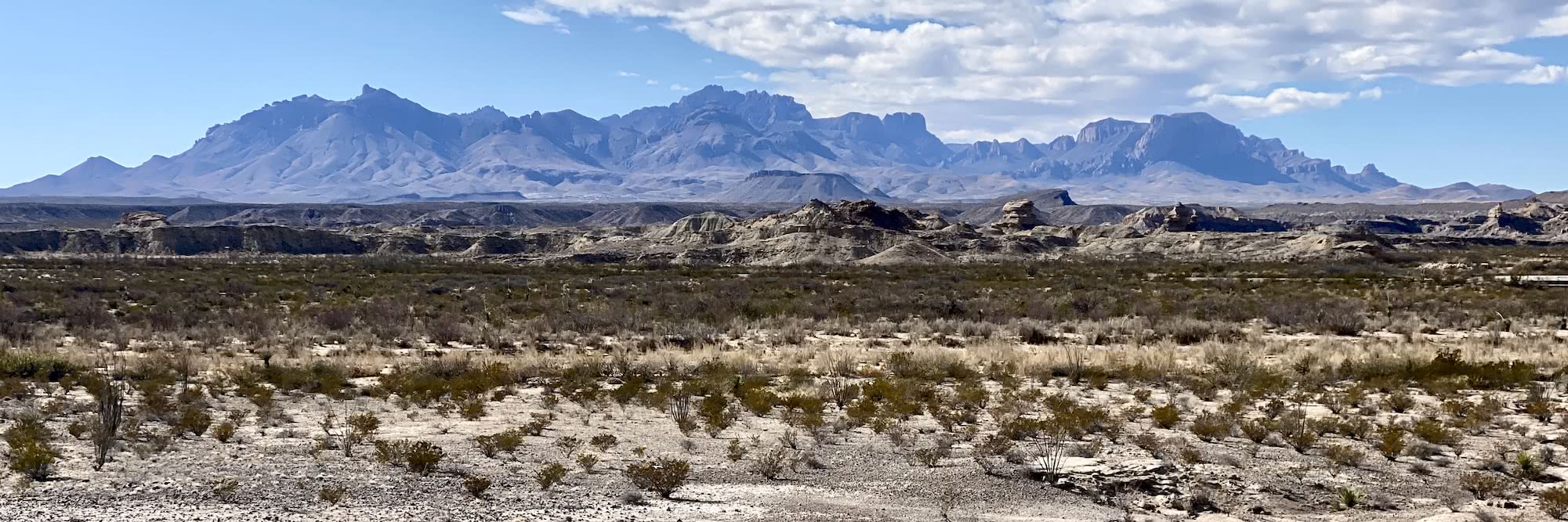
Big Bend National Park was established in 1944 and is located in the remote desert of southwest Texas along the US-Mexico border. The park’s elevation ranges from 1,800 feet at its lowest point to 7,832 feet at its tallest peak. Named for the curve in the Rio Grande river as it flows through the park, it is scarcely visited due to its location - we will admit, it was a little bit of a pain to get to, but well worth the flight and long drive to experience this unique park.
Big Bend offers a variety of scenery and hiking options in the Chisos Mountains, Rio Grande, Chihuahuan desert, several canyons, hot springs, and more. When planning any hiking trip it’s easy to get overwhelmed by all the options, but this park made things easier for us as it is divided into three main areas: Chisos Basin, Rio Grande Village, and Castalon. We booked our campsite in the Chisos Basin area since this is where the majority of the hikes are located, and who can pass up camping in the mountains? We planned to visit each of the three areas to take in all the park has to offer!
Day 1: Getting there and Lost Mine Trail
We flew out of Minneapolis to El Paso, Texas on Wednesday night, stayed in a hotel, then headed for the park bright and early Thursday morning. We were on the road by 6am, coffee in hand, prepared for the long 5 hour and 15 minute drive ahead of us. The trip was mostly uneventful, and we passed by a bunch of small Texas towns and a couple of border patrol checkpoints. Finally we made it to the park entrance! We swung by the visitor center at Panther Junction to check things out, then headed over to Chisos Basin to set up camp. The scenery as we drove up and over tall rocky passes and into the basin had us oo-ing and ahh-ing the whole way, and we decided very quickly that this was the coolest developed campground we’ve ever stayed in. Situated at 5,400 feet elevation, it was surrounded on all sides by tall rocky cliffs that sloped sharply down toward the campground. We had campsite #47, which in our opinion was one of the best in the campground. It was more secluded than the other campsites, and also had a sun shelter, bathrooms closeby, and awesome 360 degree views. We were used to having bear lockers at campsites but one interesting thing about Big Bend is that it is home to Javelinas - we didn’t see any the whole weekend but it was fun to know they were running around somewhere looking for food!

After camp was set up we made a quick drive to the Lost Mine Trailhead (very close to our campground). The trail was 4.8 miles roundtrip with about 1300 feet elevation gain, and worth every step! Right away we noticed how different the terrain at Big Bend was compared to other national parks we’ve been to - I kept asking myself, “Where are the pines?” At a glance Big Bend may seem barren and devoid of life, but if you do a double take will see all kinds of unique plants and birds chirping just about everywhere you look! The trail alternated between shade and sun exposure, and we hiked on slowly gaining elevation over the rocky, clay path. It was a warm 70 degrees and we were absolutely loving it (it was 2 degrees when we left Minneapolis the night before, haha!)

Soon the views started opening up and we took in the beauty of the steep cliffs, craggy, oddly-shaped peaks of the mountains, and the evergreen-colored shrubs dotting the cliffside. We continued hiking and the views got even better, giving us a better look at Juniper Canyon with the mountains and rolling foothills of the South Rim in the distance. The trail continued to ascend, a little steeper at that point, and we were thankful for bouts of shade and other hikers who told us we were almost there. The trail eventually leveled out at the top giving us panoramic views of the mountains towering over us. We hiked around the top and scrambled around some rocks, trying to make it as far as we could (safely) go, until the end where it turned into a big flat rocky surface with some unique rock formations along the way. We pulled out our chairs (we upgraded to ultralite chairs that fit in our day packs!) and had a seat while we snacked, hydrated, and took in the views. After our break we hiked back down to the trailhead in great time, picked up some supplies from the nearby camp store, then returned to camp.

We cracked a couple local beers to celebrate our first day (pop top cans, which we never had before), ate our dinner, and watched the mountains turn gold, then pink, then dark. There are no campfires allowed at Chisos Basin due to “extreme” fire danger, but we sat in our chairs and had a nightcap (delicious boxed wine), then retired to our cozy tent. It was a very windy night, and our tent well kept collapsing in towards us at times (which was a little creepy)! We didn’t get the best night’s sleep, but our tent held up great!

Day 2: Hot Springs, Boquillas Canyon, Dinosaur Bones, Balanced Rock, The Window
We got up early, made coffee to go, then headed toward Rio Grande to soak in the hot springs! It was about an hour from Chisos Basin to our destination, and there were two other cars in the parking lot when we arrived. The air was cool and crisp, but the sun felt warm on our skin. We changed into our swimsuits then hiked the short trail to the springs, and saw several roadrunners on the way! We passed by several old buildings as we walked along the flat, sandy path, and admired the tall rocky walls bordering the trail. It was a quick walk and we were there before we knew it - there were two other couples already there when we arrived, and a retired couple from Nebraska stuck around for a little while and chatted with us. Then they left, and we had the springs all to ourselves for a while. It was a hot 105 degrees, and it felt so nice to just relax, sip our coffee, and listen to the sounds of the river rushing by.

After a while the heat got to be too much for us, and we headed back to our car. Our next stop was a short hike through Boquillas Canyon. After a quick climb up a dusty open ridge, we hiked into the canyon and were lucky to have it all to ourselves for part of our hike. The water flowing through the canyon formed the border between the US and Mexico, and we were serenaded by a local on the other side of the canyon as we hiked through and explored, along with a “Hola amigos good morning!” (followed by a solicitation to take a ride in his canoe, no thank you! Haha). After a short flat walk we made it to the end of the canyon, spent a few minutes staring up at the tall canyon walls, and explored around the riverbank, then turned back the way we came.

Our next stop was to the dinosaur exhibit - for those of you who know me (Ashley) well, you know I was obsessed with dinosaurs as a kid (and to be honest, still am!) We learned so much about the park and its history at this exhibit. About 100 million years ago, Big Bend was actually covered by water forming a shallow sea - hard to imagine looking at it today. Then the Rocky Mountains started to rise and Big Bend was moved to the coastline, and as the mountains rose higher the park moved farther the park moved farther and farther inland. After about 50 million years, the park saw a rise in volcanic activity, bringing an end to the dinosaurs’ reign and the beginning of the era of mammals. We learned the entire Chisos Basin used to be one big volcano - the tall Chisos Mountains and rock formations that stand today are all that remains of the volcano. After checking out the exhibit we took a short paved trail to a beautiful lookout of the vast desert all around us. We really enjoyed reading about the park’s history and looking at models of the dinosaur bones found right here in the park, including a (huge) thigh bone which stood taller than both of us!

We moved on to Balanced Rock Trail, which was on our way back to Chisos. This was a classic Big Bend hike, one of our favorites, and is a must-do if you’re ever in the park - although the unpaved road to get to the trailhead was a real trip and our poor Kia Rio had a tough time! Eventually we made it to the trail. It was mostly flat at the beginning, situated right in the middle of a valley with tall peaks and unique rock formations on both sides. Our feet sunk in the sand at times, making for a more taxing hike than we expected, and the strong wind gusts swirled sand around the air. Eventually the nice flat trail brought us to the base of a rock formation, and then the scramble started. It was very well-marked, and the views along the scramble were incredible and kept getting better the higher we climbed. Finally we made it to Balanced Rock - an orange yellow rock sitting perfectly on top of two rocky pillars, forming a window looking out into the tremendous desert that seemed to go on forever.

We headed back to camp, got some snacks, then got started on our last hike of the day which conveniently started in our campground: The Window. The hike started out on a gradual decline headed toward the big V-shaped rock formation at the edge of the basin. We took in nice views of orange-red glowing mountains, then hiked into a mixed forest which reminded us a lot of fall in Minnesota - oak, pine, and cedar trees surrounded us on this portion of the hike, and if it weren’t for the cacti along the way we would never believe we were in the desert! The trail continued into a canyon, and we crossed some small streams and climbed up and down stone steps. At this point the wind really started to pick up, and next thing we knew we were at The Window - it was so windy the mist from the stream and waterfall flew through the air, and we scrambled to the very edge, looked out at the horizon, took a few pictures, then got the heck out of there! We hiked uphill back to our campsite, then took some wine to go and went to the visitor center to try to catch a sunset. We walked along a short paved path called Window View (not to be confused with “The Window” trail which we hiked earlier) to a beautiful overlook of The Window and stuck out the cold and wind as long as we could before heading back to camp to get some sleep! It was a very, very windy night - our tent held up pretty good but Joe’s side kept caving in during big gusts, and we had to get out of our tent and rig up a couple of guy lines and some paracord to support the Joe’s corner. Our handy work wasn’t half bad and we didn’t have any more issues with the tent for the rest of the night, but the howling wind and sand flying around the tent made it a little hard to get quality sleep!

Day 3: South Rim & Emory Peak
We were up bright and early just as the sun was coming up, ready to start our longest and toughest hike of the trip. Our plan was to hike the whole South Rim, a loop trail, and add in the Emory Peak spur trail which would add another three miles or so. We were unsure exactly how long this would make the hike - we had read online it would be anywhere from 12-20 miles and couldn’t get a clear answer so we decided we would just play it by ear. It was a chilly morning and we started out in hats, gloves, and our warm jackets. We hiked clockwise through the Pinnacles Trail and started ascending right away. We ran into two other hikers who clarified the total trail distance, around 15 miles altogether with Emory Peak, and we decided to go for it! The trail kept climbing and we got to see the remnants of a sunrise coming up over the horizon. We passed by a lot of backpacking campsites, then made it to a big open flat area with tall grass and views of the Pinnacles, rocky formations rising up on the slope like fingers. We continued on the shady trail, then got on the spur to Emory Peak.

It was steep, rocky, and even icy/snowy in some spots - luckily we are both experts at trying to walk on ice and snow (good old Minnesota). The trail followed an open ridge with really nice views of the mountains around us and the valley far below. The sun was shining and we started warming up a little bit, and we were surprised at how green everything was up at the higher elevation. Next we got to the rock scramble up to the peak - it was a little tough in some spots, but overall not bad and it went pretty quick! Finally we made it to the top - a small summit with beautiful views of Casa Grande, Toll Mountain, lots of other rock formations, and our campground in the basin far below. We enjoyed the views, then headed back down to the main trail. We rested our legs for a little while, then continued on toward the South Rim.

We hiked through another oak and pine forest, down into a gorge with frozen ponds and streams, and out into a big open rocky area which reminded us a little bit of Yosemite but with darker rock. The trail took turns ascending and descending, then became very narrow as it came out into a cool section in a grassy field with the plants up to our knees. We turned a corner and next thing we knew we were at the South Rim! We had great views of mountains far off in Mexico, rolling foothills and valleys, and unique rock formations. We set up our chairs and relaxed for a while, ate our snacks and tried to keep drinking as much water as we could. At this point we figured we had about 6 miles left. After a nice rest we got back on the trail which followed the border of the rim giving us more great views including a huge cliff protruding off the rim. The trail turned away from the open ridge, crossed over a sandy area of trail, then back into a mixed forest which reminded us of home.

We came out of the forest and back out into an open area with views of Chisos Basin. We were both feeling pretty wiped out at this point, but pushed through and finally made it back to the trailhead. Our GPS said 16 miles and 3,500 feet of elevation gained. We went out to dinner at Chisos Mountain Lodge for giant hamburgers, candy, and a prickly pear margarita for Ashley. We went back to camp and passed out early for some much needed sleep! There was minimal wind which was a nice improvement from the night before!

Day 4: Hot Springs Round Two, Lower Burro Mesa Pouroff, Tuff Canyon, Santa Elena Canyon
We slept in, made some coffee, then headed back to the hot springs to soak our poor aching bodies. We had perfect timing again - just as everyone else was leaving, and we got the whole thing to ourselves pretty much the entire time! After we’d had enough we went to the Rio Grande Village store, took a shower, then drove over to the Castalon area of the park. First we hiked Lower Burro Mesa Pouroff, a quick one-mile desert hike. We saw lots of cacti, shrubs, and beautiful striations and coloring in the cliffs ahead - brown, dark orange, and yellow in nearly perfect stripes. The end of the trail came up quick and we ooh-ed and ahh-ed at the 100 foot pouroff, a perfect semicircle carved into the cliffside formed by rushing waters during the rainy season and flash floods. We had fun taking lots of pictures, then went back to the car.

Our next stop was Tuff Canyon - narrower and deeper than others in the park because of the volcanic material lining the canyon. We hiked to two of the overlooks, then took the trail to the canyon floor. It was really cool to see the different types of rocks at the bottom and sides of the canyon, especially the volcanic tuff. Eventually the nice flat canyon floor hike turned into a scramble, and it was fun to climb up and over the big boulders to see how far down the canyon we could get. We had the whole thing to ourselves! Eventually we could go no farther, the rock was too tall and sheer to climb up over it. We gave up and hiked back to the car, headed for our last hike of the trip.

We saved one of the best hikes for last: Santa Elena Canyon. We drove all the way to the end of the Ross Maxwell Scenic Drive to start our hike, but first we stopped at the scenic overlook. The size of this thing was just so incredible, we could see it coming from miles away! Picture a huge, level wall of rock going on and on, with a narrow slit right down the middle. It almost looked like a brownish-red front of storm clouds,or if there are any Game of Thrones fans out there, a red/brown “Wall”. After taking in the canyon from afar, we drove to the beginning of the trail at the mouth of the canyon. The trail started across the river, and we had to cross over a shallow section of stream and do quite a bit of scrambling up and over the river bank to get on the trail - I guess the last flash flood washed away the normal trail entrance. After that little detour the trail was pretty easy, and we hiked up some switchbacks then proceeded to hike straight into the canyon! It was a completely different environment in there - lush and green with tall leafy plants and birds everywhere, topped off by the 1,500 foot canyon walls towering over us on both sides. It was shady and cool, and felt like we were walking through a rainforest. We lingered in the canyon for a while, sad that this was our last hike of the trip.

We went back to camp, started packing up as much as we could, then went back to the lodge to watch the Packers playoff game! We were shocked when they told us they didn’t have the right channel to watch the game…so we went over to the restaurant and streamed it on our phones, the spotty wifi and minimal service making the players look like green blobs…but it was worth it, because they won! Of course they would go on to lose (badly) to the 49-ers in the NFC Championship, but, oh well (we didn’t know that at the time). Either way a Packers win was a great way to top off the trip.
Day 5: Heading Home
We got up early Monday morning, finished packing up, and started our long drive back to El Paso. We saw lots of wildlife on the way out of the park including two coyotes! We made it to the airport obnoxiously early, and sat at the bar reflecting on our trip. Big Bend was absolutely amazing and unlike anywhere we’ve ever been. It was just a short weekend trip, only 3 ½ days spent actually hiking in the park, but we were really happy with all the hikes we were able to do and felt that they encompassed the park very well. We decided it is definitely a place we would like to come back to someday.
Both of us agreed that our favorite hike in the park had to be Emory Peak - the entire South Rim trail was gorgeous, but there’s nothing like the accomplished feeling you get making it up to the summit and knowing you’re standing on the top of the park! It was very challenging doing the whole thing together but it was well worth it. As far as favorite shorter hikes go, Ashley’s favorite was Santa Elena Canyon and Joe’s was Balanced Rock. One thing that still amazes us about Big Bend was the variety of different types of hikes in the park - we went from standing on the very top of the park on a cold, windy rock down to the river’s edge sitting in our swimsuits! There truly is something for everyone and every ability level.
As far as advice or things we would do differently next time? One thing would definitely be secure the tent a little better right away instead of getting up in the dark to do it once the tent has already caved in (haha). Definitely bring clothes for any and all types of weather and temperatures, we were glad to have t-shirts and shorts as well as pants and jackets - although next time we’ll probably leave our rain gear at home. Make reservations in advance, as there were a lot of people at the visitor center when we checked in hoping to get some walk-up campsites but most of them were booked - another option is staying at a “primitive” campsite. There are several located around the park, they are drive up campsites with room for only one group which provide a lot of solitude but you need a 4x4 vehicle to get to most of them! We thought this would be something cool to try next time we come.
If you’re looking for an awesome winter hiking destination, look into Big Bend National Park! You won’t be disappointed.

Thanks for stopping by - check out more pictures in our gallery.