Utah’s Mighty Five
Utah
Meet Utah’s Mighty Five - Zion, Capitol Reef, Arches, Canyonlands, and Bryce Canyon National Parks. It was an amazing nine days spent road tripping across Utah, and we can’t wait to tell you all about it!
Zion National Park
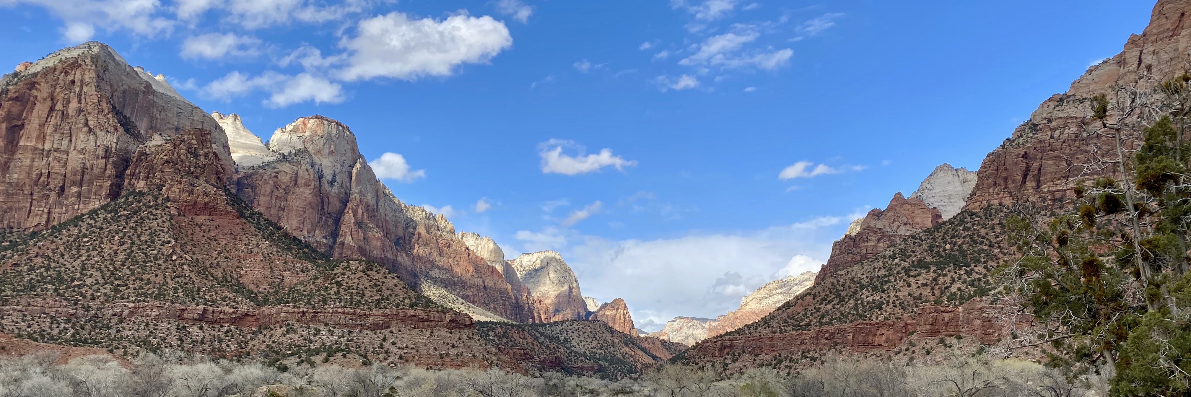
The first stop on our trip was Zion National Park - best known for its beautiful canyons, red rocks, and gorgeous scenery. I (Ashley) have been there before on a girls trip a few years ago and remember feeling completely stunned by how beautiful it was - needless to say I was excited not only to go back and see for myself but for the two of us to go together! We left (extremely) early Saturday morning, flew into Las Vegas, picked up our rental car, and hit the road! It was about a 3 ½ hour drive to the park and we were there by mid-afternoon after stopping for groceries and supplies. We set up camp, had some snacks, and looked over our hiking itinerary. Several trails in Zion were closed due to some recent rock falls, but most of our top choices were still open. We hopped on the free shuttle and started on the Kayenta Trail to Upper Emerald Pool.

The trail was a moderate two mile out-and-back hike, made to feel extra difficult because of our sleep-deprived brains. The pool itself at the end of the hike was pretty cool, but our favorite part of the hike was the view of the canyon along the trail with the Virgin River flowing through it (picture above!) It was a beautiful spring day and the bright blue sky paired nicely with the deep red rocks and green trees along the canyon. We took the shuttle back to the campground, then made a gourmet dinner of hamburgers and sweet potatoes on the campfire topped off with a local brew. Next thing we knew we were asleep in our tent, a great first day under our belts!

We slept in Sunday morning, had some breakfast and coffee, then went down to the local outfitters to get some advice on our next hike. We planned to hike The Narrows, an absolutely epic hike up the Virgin River, but needed to check on the weather. It was sprinkling a little and there was a chance for rain later in the day, but the guides said we would be safe to go as long as we got going quick! We rented all the gear we needed - including a walking stick, water shoes and socks, and waterproof overalls - then hopped on the shuttle! We took it all the way to the very last stop, Temple of Sinawava, made our way down the short paved trail to the river, then got into the water!

It started out about shin deep, and over the course of the next couple of miles it would vary from a sandy path above water level to chest-high water! The walking sticks really helped us keep our footing, especially when we had to cross to the opposite side. We admired all the different colors of rock, black gradually fading to brown, amber, orange, and yellow, some areas were very polished and smooth while others were jagged. Every now and then we spotted a blue or purple rock in the riverbed, and all the rocks seemed to shine extra bright with the water flowing over them. All the colors and textures meshed so perfectly together, yet when we took a closer look, no two rocks were the same. There were deep gouges in some areas of the canyon, and the steep walls towered over us throughout the whole hike. We made our way up river slowly but steadily, and then the gentle mist spitting down on us most of the hike turned into a steady rain, and we decided it would be safest to turn back. There’s always the risk of flash floods in the canyon, and we didn’t want to press our luck by continuing on in the rain.

We went back to camp, had some lunch, got a beer at the local taproom, and learned a lot about Utah’s liquor laws - you must order food with alcohol in a restaurant, and no beer greater than 5% alcohol. After our nice break we set off to hike the Watchman Trail, which left from our campground. It was a moderately difficult 3.3 mile hike with gorgeous views of the rock formations and deep canyon around us. It was sunny and beautiful out by then, and most of the trail was out on an open ledge which gave us nearly continuous views. Our favorite part of the trail was the very end when we got our closest views of the Watchman formation and a bird’s eye view down the canyon. We took our time at the end of the trail admiring the jagged canyon walls alive with color. Watchman is probably one of the most underrated hikes in the park - it was a lot less busy than the other (more popular) trails, but the scenery is absolutely beautiful and it shouldn’t be missed! We headed back to camp, had dinner, and sat around the fire while we watched the sun set over the Watchman formation right from our campsite. Watchman Campground is definitely one of the more scenic campgrounds we’ve stayed in - it sort of reminded us of Big Bend where there were mountains on all sides.

Monday morning started out bright and early - we had camp all packed up and were waiting in line for the Zion shuttle at 7am, wanting to get a head start on Angel’s Landing before the crowds. Arguably the most popular trail in the park, even the first shuttle of the day was packed full. The hike started out with 21 switchbacks named “Walter’s Wiggles”. Our legs were killing us but the views of the canyon got better and better the higher we climbed. What started out as a rat race of people rushing toward the top, eventually became a much calmer hiking experience, since the switchbacks and intensity of the incline helped to thin out crowds! Finally the switchbacks came to an end and we started the scramble - composed of steep drop-offs, sandy, slippery rock, and a chain to hold most of the way.

Overall the scramble wasn’t too bad, but there were definitely a few nerve-wracking parts where we were really thankful to have the chain to hold onto! It only allowed for one-way traffic due to how narrow the path was, and passing other hikers or having other hikers pass us was quite the event trying to move out of the way! We even felt confident enough to take a few photos and videos on the way up (don’t worry everyone we were holding on tight), and we just couldn’t get enough of the panoramic views of the canyon and Virgin River all around us. Then we made it all the way up to the top and words could not describe the views from up there - just stunning. We sat at the top and had breakfast, taking in the beautiful red and orange cliffs tumbling down toward a valley lush with green trees and shrubs. We took in all we could, then made ourselves head down to try and avoid the headache of dealing with one-way traffic as the trail got busier. The hike down was uneventful, and once we got back to our car we drove out the east entrance of the park along the Zion-Mt. Carmel Scenic Drive to our last hike of the trip: Canyon Overlook Trail.

Canyon Overlook was an easy 1 mile hike out to a gorgeous, steep canyon, and along the way we got to see how different the east side of the park was compared to the more popular west side. We saw the Checkerboard Mesa - a large rock formation with vertical and horizontal striations formed by sand dunes and sandstone cracking during winter. After one last look, we hopped back in the car and made our way to Capitol Reef!
Overall Zion was an incredible experience. It was by far the most scenic park of the trip, the park itself is very well-organized, and there are tons of services very close to the campground and visitor center. The shuttle system was a breeze to use, we never waited longer than a few minutes and it was nice not having to worry about finding a parking spot at trailheads. Everything in the park was situated close enough together that we were able to walk from Watchman Campground to the visitor center, brewpub, outfitter, and general store. If we had more time, we could have even taken a free shuttle from the visitor center into the town of Springdale for some shopping or restaurants. The only negative thing we have to say about Zion is the sheer volume of people there - the campground was full of people (and quite loud at times if we may add), the trails were very busy especially later in the afternoon and on the weekend, and we heard someone say that Zion in the summertime is “utterly unenjoyable” due to how busy it is. The beauty of this park should NOT be missed, but when you’re planning your trip just keep in mind the time of year. March was a very nice time to be there, but we did have a bit of rain, and the temperatures did get a little cold at times! We decided that in an ideal world, September or October might be a nice time to go.

Capitol Reef National Park
Capitol Reef is about 3.5 hours away from Zion, and we made it to the park on Monday afternoon around 4:30 or so. Right off the bat we were blown away by the huge rock formations towering over the road and the bright pink, red, and orange landscape topped off by white-capped mountains in the background. Almost like the surface of mars, fine red clay covered the ground. As we drove through the park on our way to the campground, we found the vibe in Capitol Reef to be very ranch-esque. There is an orchard where you can pick fruit when in season, lots of old ranch houses, and a horse stable right next to the campground - like a wild west movie! We set up camp and then drove to Panorama Point, and hiked the short trails to Goosenecks overlook and Sunset Point. The Goosenecks are the names of the tight bends in Sulphur Creek and the steep canyons formed by the erosion of the creek over time. It was really cool to look over the edge and see the creek snaking sharply through the deep canyon. Panorama and Sunset Points had incredible views of the surrounding landscape - deep red dirt and huge rock formations and cliffs as far as the eye could see, with big white-capped mountains off in the distance. We headed back to camp, made some dinner over the fire, and enjoyed sitting around the fire until it got too cold.

We slept in Tuesday morning, had some breakfast and coffee, then went to the visitor center for some hiking advice. No matter how much we research a park ahead of time, we always swing by the visitor center to talk to rangers and get their opinions! Unfortunately we didn’t have the best outlook on weather - it looked like we would just have one day, because Wednesday was forecasted to rain all day. Unfortunately that’s the kind of thing you just can’t plan for - we were happy to at least have one full day with good weather, but this also meant we needed to prioritize which hikes we wanted to do (with so little time!). We took the recommendations from the ranger in stride with the hikes we already had planned, and eventually settled on a couple of mid-length hikes to try. We started with Cohab Canyon and Hickman Bridge. Cohab started out near the campground and right away we hiked up switchbacks that took us high on the canyon wall, giving us great views of the rocky mountains around us as well as the barn and horses near our camp! Next we hiked into the canyon - the trail followed the center of the canyon, high red-orange walls on either side riddled with Tafoni formations, giving the rock a Swiss Cheese sort of appearance. The trail took us deeper into the canyon and we admired the different colors and shapes of the rock as we hiked.

Then we took a spur trail to a north and south overlook, both of which offered amazing views of the surrounding landscape. We stood out on the ledge for a little while admiring the views, then hiked back along the grassy plateau to the main trail. The canyon widened a bit then, and we walked across big flat rocks, through fine sand, then up and down more switchbacks until we got to the road and turned onto the Hickman Bridge Trailhead. It was about a mile to the bridge, and along the way we enjoyed looking at more Tafoni formations in the rock, climbed up some switchbacks, then descended down into a canyon where we reached the bridge. We had some lunch, then on tired legs hiked all the way back to camp. We really loved this hike not only for the scenery, but also because it was very peaceful and quiet. Next we took the car down the scenic drive through the park - lots more cool cliffs and rock formations, and the route ended on a dirt road through the canyon. The road got very narrow in some places, and was a little muddy, but our rental car made it through okay! At the end of the road we hiked the Capitol Gorge Trail to the “tanks”, and even saw some petroglyphs along the way! The trail through the gorge was really neat, but if we did it again we wouldn’t hike the extra jaunt to the tanks. We went into town to get some supplies, then decided to try one more trail before the rain rolled in.

Our last hike in Capitol Reef was Chimney Rock - a 3.6 mile loop. It was tough, but it was one of our favorite hikes in the park and a perfect finale to Capitol Reef. We could see Chimney Rock from the parking lot, a big red rock formation which did in fact resemble a chimney! First the trail took us up to a better view of the surrounding landscape and brought us level with Chimney Rock, up on top of the plateau we stared at from the parking lot. The trail followed the top of the canyon wall, and we could see for miles and miles. We continued hiking along the ridge and were treated to panoramic views of Capitol Reef and the white-capped mountains in the distance. The deep reds and rust oranges of the landscape contrasted against the green vegetation and white snow on the mountains made for a picture perfect combination. It was one of our favorite views of the trip! We finished the loop, exhausted, and went back to camp for dinner, drinks, and some much needed sleep.

We set an alarm early Wednesday morning in an effort to pack up camp before the rain rolled in - somehow we pulled this off and were driving out of the park just as it started! Before leaving, we stopped by a Petroglyphs exhibit but it was so dark we could barely see anything…we did see one clear carving of deer antlers though! Haha.
We had an incredible time at Capitol Reef - one of our favorite things was the overall vibe of the place, ranch-esque and very laid back as we said earlier in this post. We also loved the fact that it was much (MUCH) less busy than Zion, in fact there were some hikes where we didn’t even see another person. One downside is it’s a smaller park, and services are at least 20 minutes out of the way if you need groceries or firewood. It was a little on the chilly side in March (in fact the campground had just opened up for the season), so next time we will definitely come later in the year - maybe even when there is fruit in the orchard! There are pros and cons to any time of year though - we loved having so much quiet time and a lot of trails to ourselves.

Arches National Park
We stopped in Green River for a delicious breakfast on our way to our next park, then continued on the highway toward Moab, UT, a town situated right between Arches and Canyonlands. We showered in Moab which felt amazing after several days of camping, and drove through Canyonlands first only to find it was a complete whiteout of fog and rain. Luckily Arches and Canyonlands are only about 45 minutes away from each other, so we turned back and headed to Arches National Park hoping for better luck. We swung in the visitor center, then to The Windows Trailhead. To our delight, the weather was much better at Arches with just a little bit of mist and fog, but we could still see the arches almost perfectly. We hiked to the North and South Windows and the Turret Arch, which was a great introduction to the park. The North Window was the coolest because you could stand on the bottom and the view through it was beautiful - lots of cliffs, ridges, rock formations, and valleys. Then we drove to the trailhead for Delicate Arch - this is the one you see on all the Utah license plates and pretty much any advertisement for Arches National Park (and for good reason, it was absolutely gorgeous). The hike was 3 miles long and moderately strenuous, including a tough ascent over a big area of slickrock. Next the trail hugged the cliffside on a narrow ledge, and then we were there! The arch was breathtaking, standing alone in a big area of slickrock, tall and slender - “delicate” was a very appropriate name for it. The views through the arch were also beautiful, and the landscape was so vast it seemed to go on and on. We took some pictures with the arch, then had a snack and enjoyed the view. It was a quick hike back to the trailhead, and then we hiked to another overlook of the arch.

Finally we drove to our campsite in Devil’s Garden Campground - site #2, which in our opinion was the best one there! It was super isolated from all the other campers, had a tent pad hidden off on its own behind some trees, it was close to the bathrooms, and it was close to the campground entrance and the most popular trailhead in the park. The campsite was also surrounded by large rocks, and we climbed up on top and ate our dinner up there as the sun came down. We drank our local brews and admired the red-orange desert and the white tops of the La Sal Mountains, which seemed so close it felt like we could throw a rock and hit them! Once the sun went down we sat around the fire and stargazed a bit, then turned in for the night.

We slept in Thursday morning then walked from our campsite over to the Devil’s Garden trailhead. Our plan was to hike the 7.9 mile loop, including a primitive trail (meaning it’s not maintained or well-marked and requires some scrambling). We started on the primitive side going counter-clockwise, and it started off pretty normal, not super well-marked but overall easy to follow. Some thick fog had started to roll in, and it gradually started lifting and we could see more of the landscape around us. We learned about how these amazing arches formed - it started with some cracks forming in the sandstone, gradually widening over time creating parallel rocky walls called fins. Eventually water settled into the sandstone, and the pressure from water freezing caused cracks and the sandstone started to flake and crumble, forming holes in the middle of the fins. And there you go, that’s your arch! Next the trail took us into a narrow canyon, and the trail just seemed to stop. We looked around for cairns (little rock piles) to mark the way and realized the trail actually zig-zagged up the SIDE of the canyon. The canyon wall was slick due to the smooth rock covered by sand, and had a very steep grade with only a few flat spots for footing. We decided to give it our best try and got about 30 feet up, then got stuck. We were almost over the wall but couldn’t see any safe way to do it - it was one of the most scary experiences we’ve had hiking, 30 feet off the ground on a steep slope with seemingly nowhere to go. We tried to find a way for probably 20 minutes, then threw in the towel and turned around. It was disappointing, frustrating, and exhausting, and both of us were upset we weren’t going to be able to complete the loop. In the end we agreed we made the best choice to walk away- better to turn around disappointed than to end the trip early with a broken arm or leg.

We returned the way we came, then started the loop in a clockwise direction. The first stop was Landscape Arch, 306 feet long and only about 11 feet thick. Next the trail continued as a “primitive” trail again, but nothing like before. There was still some scrambling and climbing over slickrock, but not nearly as steep or slippery! We saw Navajo Arch and Partition Arch, and then hiked over this huge rocky “bridge” along the trail. It definitely took a lot of route-finding and we found ourselves off trail more than once, but we always made our way back. The fog had completely cleared and we had great views of the La Sal Mountains rising high over the horizon, their white caps blending in with the clouds. We continued hiking and saw Double-O Arch which was one of the coolest of the trip, then hiked to the end to Dark Angel which in all honesty we were not super impressed with - it didn’t help that we were exhausted by this point haha! Once we finished the hike we went into Moab for supplies, then contemplated our next move. Unfortunately Friday forecasted rain all day, and we still wanted to do some hiking in Canyonlands. So despite how tired we felt, we went to Canyonlands to soak in as much as we could before the rain rolled in again.

Overall Arches National Park was amazing - so unique compared to anywhere else we have been. It was definitely a busy park, arguably just as busy if not even more busy than Zion. Our campsite at Arches was our favorite of the trip because it was so isolated and private, and had amazing views. We felt like we were able to see a good amount of the park with the time we had, but it would have been nice to have an extra day of good weather. Delicate Arch was definitely our favorite, but the whole park was beautiful and it was nice being so close to a big city like Moab for things like supplies, hanging out at a brewery, and things to do on our rain day! More on that later in this post.

Canyonlands National Park
We only had a few hours in Canyonlands, but it was such a unique place and we would love to make it back someday. Unlike our first attempt to hike at this park, the weather was absolutely perfect with clear blue skies. We focused on the Island in the Sky area - the most popular area of the park with lots of hiking trails. We started with Mesa Arch, an easy ½ mile loop that led us to a beautiful free-standing arch with amazing views of a deep canyon and the La Sal Mountains through the arch opening. We took in the views for a while, then moved onto Grandview Point. We stopped at the overlook then hiked along the rim for about two miles roundtrip. The views from both the overlook and the rim were amazing - we saw the La Sal Mountains, Abajo Mountains, and a series of deep canyons carved by the Colorado River. One thing we really liked about Canyonlands was it seemed to be like a canyon within a canyon (within another canyon) - so many different layers and levels, and deep enough that we couldn’t even see the river!

Then we drove to a few overlooks for more views, starting with Buck Canyon. This was one of our favorites as it had the best views of the La Sal Mountains and a deep V-shaped canyon which started narrow and grew wider and wider. Next was Green River Overlook, which was another good example of canyons within canyons. Then we hiked Upheaval Dome - essentially a big hole in the ground with salt ridges rising up inside of it. How it formed is kind of a mystery, they don’t really if it’s from a meteorite or a slow-moving salt dome. Either way, it was cool! Last but not least, we drove to Shafer Canyon Overlook, which was so wide and deep with those La Sal Mountains peeking up over the horizon again! We ventured out onto a little rocky outcrop and took in the views.
Overall Canyonlands was an amazing park, very beautiful and unique. Next time we would love two full days - this would allow us to explore the other areas of the park including Needles and Maze, as well as do more hikes in Island of the Sky. There were a decent amount of people in this park, nothing like the business of Zion or Arches, but not quite as private as Capitol Reef.

We headed back to camp for some dinner and drinks, then watched the stars again around the campfire. We slept in Friday morning - it was forecasted to rain on and off all day. We made coffee and brought it into our tent while we relaxed a while, then napped a little and read our books before we decided to head into Moab for some breakfast. We ate at Eclectica Cafe and each had a delicious brunch burrito, then walked around downtown Moab and checked out a bunch of local shops. We went to Moab Brewery and had some drinks, and learned even more about strange Utah alcohol laws - for example, they could not serve us a flight of beer to share because each person can only have 2 alcoholic drinks at a time. We browsed through some more shops, then went back to camp for our last night in the tent.

Bryce Canyon National Park
We slept in Saturday morning then drove to Bryce Canyon, about 4 ½ hours away. Bryce Canyon is situated at a higher elevation compared to the other parks ranging from 8,000-9,000 feet, which meant colder temperatures and even snow! We knew this ahead of time so we made sure to reserve a hotel instead of planning to camp. It was also nice to look forward to the luxury of sleeping in a bed at the end of our trip! We checked into Ruby’s Inn, our home for the night, which conveniently was less than a 10 minute drive from the park’s visitor center! We swung by the park to get some souvenirs and information from the rangers, then drove to a few overlooks to take in some views. Bryce Canyon is a magical place, especially in the winter, but this also meant a lot of trails were closed because of ice, snow, and rockfall. A lot of roads were closed in the park too (again because of the snow), which meant that the majority of the park was not accessible to us…BUT we had an amazing time and it was absolutely gorgeous with the snow. We drove to Bryce Point and Inspiration Point, then went back to the hotel for some dinner and relaxation time.

We slept in Sunday morning, had breakfast, then went back to the park for our hike. We parked at Sunset Point, hiked over to Sunrise Point, then hiked part of the Queen’s Garden trail as far as we could go before the trail closed and we had to turn around. The trail took us around the rim between Sunset and Sunrise, then down into the canyon to hike among the hoodoos. Hoodoos are amazing tower-like rock formations formed by freeze-thaw cycles and rain showers. Each one was unique, but they all had this amazing, deep orange color. The hike was muddy and wet and we were happy to have poles and spikes. We hiked back out of the canyon then back to our car. We drove back to Las Vegas, spent some time at Tenaya Creek Brewery, then went to the airport for our red eye flight home!
Even though we barely scratched the surface of Bryce Canyon, it was easily one of the coolest experiences we’ve had hiking down in a canyon with the hoodoos, and the park was just beautiful to see with snow. The downside was the park was still crawling with people despite the weather, and we missed out on a big chunk of the park - again, there are pros and cons to each time of year, but we can’t wait to come back and explore Bryce in all its glory sometime in the fall.

Phew! That was a long post! Even though it was a fast-paced trip, we both agreed that we were so happy to be able to experience all five parks in one vacation. In an ideal world (that is one with unlimited PTO and money), we would have had twice as much time to explore Utah. In the end though we wouldn’t change a thing - every park was unique and special in its own way and we feel very fortunate to have been able to visit them all. We decided that there’s no way we could choose a favorite park, hike, or experience from this trip, so you’ll just have to go see them for yourself and let us know what you think!
Thanks so much for stopping by. As always, check out more pictures in our gallery!