Appalachian Trail Section Hike
Georgia
The Appalachian Trail - the longest hiking-only footpath in the WORLD. Tackling a section of such a legendary trail has always been on our bucket list, and when our old Minneapolis pals Laura and Jeremy moved to Tennessee last year, we set plans in motion to make it happen. Over the course of five days, we would hike almost 40 miles and complete less than 2% of this epic trail. It’s hard to find exactly how long it really is because of conflicting information, but according to the Appalachian Trail Conservancy it is 2193.1 miles long, gains 464,500 feet of elevation, and spans across 14 states from Georgia to Maine.
We bought a map and a guidebook, started training, did our research, and planned our route. The amazingly long trail made it tough to narrow down exactly what section we wanted to tackle - the options are almost endless. The idea of starting at the bottom and working our way up sounded great, so we decided to start at the southern terminus in Georgia and take it from there! As the trip grew closer, we checked more things off the list: booked the shuttle, dehydrated our own backpacking meals, and then counted down the days until it was finally time to leave! We took a flight into Knoxville late Wednesday night, then hit the hay to prepare for a long day.
Day 1: USFS-42 to Hawk Mountain Campsite
Laura and Jeremy picked us up at our hotel around 6:30 Thursday morning, and we hit the road headed for Hogpen Gap - our planned end point on our section hike, where we arranged to have a shuttle pick us up and take us south to Springer Mountain. It was an eventful drive, at least for Jeremy, while he was earning his trail name “Yak” (the roads were winding and Laura was motivated by the need for speed). We met Bret, our AT shuttle driver, we all packed into his SUV and away we went. It was about an hour and a half ride, which probably felt a lot longer to Yak who continued to suffer the effects of the winding roads, but at least he was feeling well enough to crack jokes and keep us laughing all the way up the mountain! Bret dropped us off at USFS-42, about a mile north of the true southern terminus of the AT, which is only accessible by foot. We strapped our packs to our backs and set off on the trail.

Not going to lie, our packs felt heavy and our legs felt out of sorts - our bodies needed a little acclimating to backpacking season! The trail was rocky and hilly, and Yak stayed back to sleep off the Dramamine that we force-fed him to help with the motion-sickness. After about a mile we made it to Springer Mountain, the southern terminus of the A.T.! We signed the trail register, read the plaques, and enjoyed the view from the top of rolling hills in the distance, the dormant forest slowly coming alive with green.

We turned around and started hiking again, reconnected with Yak, and continued northbound. The trail was easy for the first few miles, and we hiked over mostly flat terrain with generous descents and very little climbing. The forest reminded us a lot of home, but with fun, different types of trees and shrubs along the creek banks. They had twisty reddish bark and long, finger-like leaves, which we later learned was called Mountain Laurel and would bloom with a gorgeous display of flowers in the next month. We crossed over some creeks, saw lots of wildflowers, and continued hiking through the peaceful forest. We were pleased at how few people we saw - everything we read about the A.T. indicated it would likely be a zoo, but this wasn’t the case, and it was delightful. We stopped for a while next to a creek for a snack break, and it finally sank in that we were finally on the A.T. - a trip months and months in the making, finally coming to fruition.

We pressed onward, and admired that the dirt and rock seemed to glimmer in the sunlight as though it was covered in a layer of glitter! We would later learn that this is due to a mineral called mica, which gives soil and rock this sparkly appearance. Then the trail started to get tougher, and we started a climb that lasted for almost three miles. It was a rough section, alternating steep ascents with stingy flat areas or descents. We were tired and hungry, and wanted so badly to make it to camp!

Finally we made it to our destination for the night, Hawk Mountain Campsite. This was a fun campsite, composed of 30 tent pads spread out generously along a quarter mile trail, with tent pads carved out of the slope. It made for a pretty neat set up and a lot of privacy between campers. We set up camp and made dinner. We didn’t have any new gear to try out for this trip, however, we did experiment with making all of our own backpacking meals! We prepped, dehydrated, and vacuum- sealed everything on our own at home. Our first meal, chicken-fried rice, turned out delicious, and we were thrilled! Making your own meals is cost-effective, healthier, and this way you can control the portions and bring enough food to actually fill you up, which was an issue we were having on previous trips. It’s definitely a time investment, but for us it paid off! The four of us relaxed for a while then went to bed - we hiked a total of 8.4 miles. As we laid in our sleeping bags, sore and chilly, all we could think to ourselves was: Man, it’s great to be back out in the woods!

Day 2: Hawk Mountain Campsite to Spring at Mile Marker 22.1
None of us slept well Thursday night due to the “record low” temperatures in Georgia (not terrible in MN terms, low 30’s). Friday morning Jeremy and Joe disclosed to the rest of the group that during the night they heard other campers yelling something along the lines of “Get out of here!” and use noisemakers - we assumed a bear must have visited camp, but luckily our food was just fine as we used bear canisters on this trip. We packed up camp and deliberated how far we would hike. Our original plan, of course, was flawless - 8-8.5 miles per day, roughly, which would give us plenty of time to stop along the way and make it to camp at a reasonable time without getting up at the crack of dawn. Well as the trip grew closer we were blessed with a forecast that showed 100% chance of thunderstorms on Saturday. Now hiking in the rain is one of the more miserable things we have done, and we had no desire to experience that on this trip, so we made a plan to stay at camp all day Saturday and try to make up the distance over the remaining days. We are lucky camping is so flexible along the A.T. - yes there are campsites, but it runs through national forests so as long as you are on national forest land, you can pitch your tent wherever (but make sure to follow the rules and stay far enough from the trail and any water source). So, we had a rough plan to make up some of the distance Friday - and we left camp bright and early to get a jump start. It was a beautiful morning and the blue-yellow sky lit up the mountains and seemed to illuminate the whole forest. It was peaceful, quiet, and perfect.

It was around this time we started thinking that Yak’s, well, yak-ing, was maybe more than just motion sickness. He still didn’t feel well, and Laura and Jeremy made the tough decision to take a break from the trail for a couple of days so he could rest. The four of us hiked north together to Hightower Gap, and we wouldn’t see each other again until Sunday morning. Our trusty shuttle driver, Bret, was able to pick them up and take them to a hotel in town for some R&R, and we made a plan to meet back up on Sunday and continue the trip from there. The trail ascended 700 vertical feet over the next mile, and while it was tough, the gorgeous display of wildflowers and views of the rolling mountains in the distance more than made up for it. Everywhere we looked, we could see the silhouette of mountains creeping through the trees. The forest was brighter than the day before, and green foliage sprung from nearly every branch and covered the forest floor. We descended to Justus Creek, a perfect place for a lunch break. It sprinkled on and off while we rested by the creek, and if we didn’t know any better, we may have thought we were in a rainforest. The creek had a sandy, rocky riverbed with exposed roots and vibrant green plants crowded the shoreline.

As we continued our hike, the sun came out and things heated up! We crossed over Blackwell Creek, another lovely spot, then ascended up to Ramrock Mountain. This was our first real, open, overlook since Springer on our first day. We were treated to gorgeous views of green, rolling mountains which faded into a fog in the distance as far as we could see. We rested here for a while, proud of our progress thus far (10.7 miles, and still kicking!) We met another couple who was thru-hiking the trail from start to finish, and it was a little sad to think we’d have to go home in a few days. We had cell service here so we were able to reconnect with Laura and Jeremy to confirm they were in fact picked up and not stranded on the side of the road, and we finalized our plans to meet up on Sunday. We were pretty tired, and had four more miles to go to meet our goal for the day.

We crossed Woody Gap, rested again (running on fumes), then pushed on 1.5 more miles into the Blood Mountain Wilderness, and up about 600 vertical feet. We made it to Preacher’s Rock - a broad outcrop with unobscured views of mountains tumbling into a valley. We lingered there for a while, then pushed on, knowing we were so close to our end point for the day. The trail continued to ascend, like rubbing salt in a wound, and we took a spur to an overlook on Big Cedar Mountain. This too was beautiful - we took a deep breath, then continued a short walk to the spot we would call camp for the next two days.

It was a nice little spot - a flat, open area nestled in the forest next to a spring, surrounded by towering trees and huge boulders covered in moss. We were so proud - 14.7 miles and countless feet of elevation gained. Before we could even think about dinner or setting up camp, we just laid on the ground for a while. For anyone who hasn’t been backpacking before we know it might be hard to imagine feeling so tired that all your bones throbbing, but at the same time feeling so so happy to be where you are. That’s how we felt Friday night! We set up camp reinforced with a tarp to prepare for the coming storms, and made our gourmet dinner of burritos complete with tortillas, from the kitchen of Joe and Ashley Simon. Maybe it was because we were exhausted, but that food tasted delicious (no, that wasn’t it, the food was damn good). Feeling happy, tired, and full, we went to bed and it didn’t take long before we were passed out cold!

Day 3: Camp Day
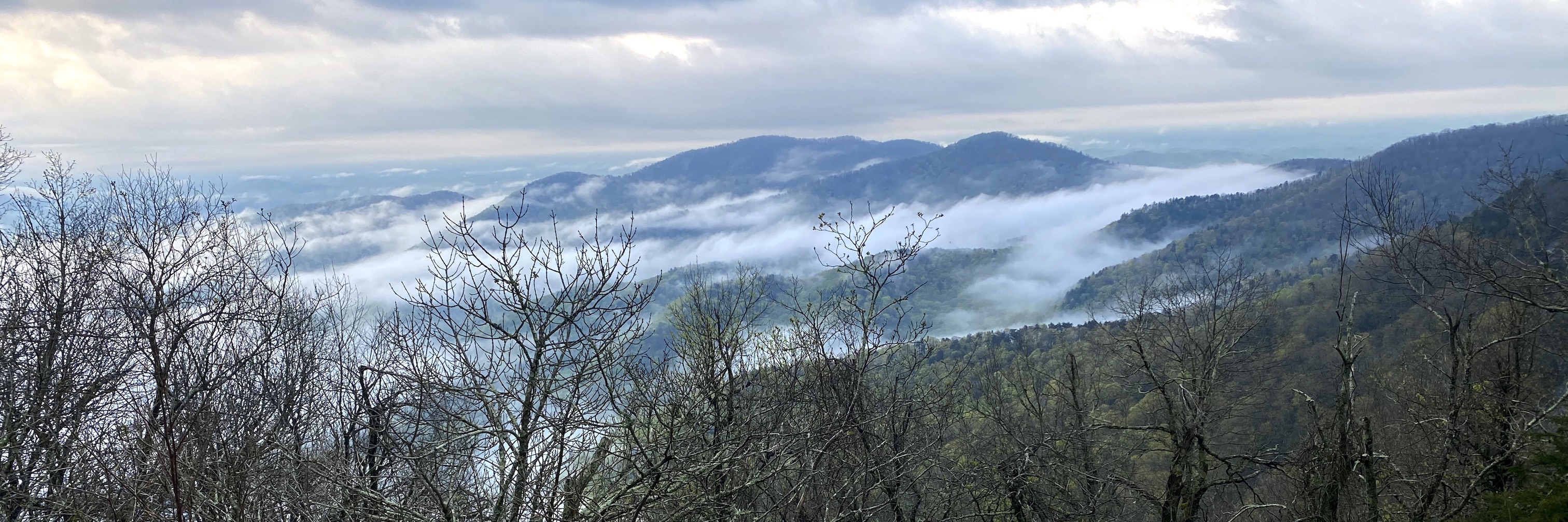
We woke up Saturday morning to the sound of rain, which we knew was coming. It felt nice to sleep in and relax after such a long day on Friday. Unfortunately our tarp setup wasn’t as foolproof as we thought - it was sagging, water was pooling near the tent, and the tent sides were covered in mud. We put on our rain gear and made some adjustments, complete with tightening the guylines on our tarp and rearranging our equipment under our rain fly. Sounds great in theory, but it’s pretty hard to stay completely dry while doing all of that. So we trudged back into the tent, cold and damp. We made some breakfast, then went back to sleep, thankful that at least we weren’t hiking in the rain. Around 3pm it stopped raining, and as we emerged from our tent we found the forest to be socked in with fog, and it was very eerie. The sun eventually came out, and we were able to hang some things out to dry. We sat outside and made dinner - a delicious homemade stroganoff - and were joined by a little snail friend who kept us company. We reinforced our tarp (again), dug trenches, and reorganized all of our stuff. We knew we had a little more time before the next wave of rain so we took a short walk back to the Big Cedar Mountain overlook - we saw the same tumbling mountains as the day before, but this time, they were draped in a blanket of thick fog that gave the illusion that the peaks were rising above the clouds, or, engulfed in smoke. We sat down on the big slab of rock and admired the view for a while, then returned to camp and bundled up inside the tent. More rain and eventually thunderstorms passed through, and we were pleased that our reinforcements held up!

Day 4: Spring at Mile Marker 22.1 to Bull Gap
It was quite windy when we woke up Sunday morning, and we braved the cold to pack up our wet camp, scarfed down some breakfast, then hit the trail. We had plans to meet Laura and Yak at Henry gap by 9am. The trail was quiet, wet, and deep green, and we hiked past a slope covered in trilliums - there had to be hundreds of them! We continued hiking and accidentally hiked far past Henry Gap…luckily we had cell service so we were able to connect with Laura and Yak and finally meet back up! We caught up and chatted as we hiked, then started our ascent on Blood Mountain. Rising to 4,459 feet, Blood is the highest peak on the Georgia section of the Appalachian Trail, and the sixth-tallest mountain in Georgia. It was definitely hard work, but not too bad, and before we knew it we were at the summit! There was a shelter at the top and a big rocky outcrop with wonderful views of the rolling mountains in the distance. We took a break for a while at the top, had some snacks, and took in the views.

The hike down from Blood Mountain was very rugged - slabs of wet, slippery rock, big boulders to step around and/or over, and we hiked slowly and cautiously down the steep declines. It probably took longer than ascending, and our knees were sore and our legs felt like jello by the time we reached Neel Gap. Neel Gap had an outfitter, and the A.T. actually crossed right through the building! We stopped there for pizza, souvenirs, and other yummy treats, and relaxed out on a picnic table for over an hour. We had a nice view of cascading green hills, and you couldn’t ask for a better day - blue skies, a pleasant breeze, and perfect temperatures.

Eventually we continued our hike, only 1.1 miles to our destination for the night. When we got there we couldn’t find the water source, and it appeared to have dried up. We didn’t want to push forward any farther, so Laura and Ashley hiked BACK down to Neel Gap to fill up our water (much easier without 30# packs), then returned to camp, at which time Joe alerted us that he had in fact found the water source (scowl). We hung all our gear up to dry, made camp, and started on dinner. A few other hikers camped across the trail from us, and a weird elderly hippie and his dog visited us at camp for a while which was quite strange (cue the serial killer jokes). Eventually he moved on, and when the wind started picking up we took shelter in our tents to get warm! It was a wonderful, productive day, a total of 10.3 miles hiking (plus an extra 2.2 for Ashley hiking back for water). It set in for both of us that the trip was officially going to be over in one day, and we felt that we just weren’t finished! We were just catching our stride, the hiking felt great, and we both agreed we could have kept going for a few more weeks! It’s always sad when a trip comes to an end, and we daydreamed about the possibilities of thru-hiking (or at least doing a very long section hike for several weeks). We savored every minute and prepared ourselves for one last day of hiking.

Day 5: Bull Gap to Hogpen Gap
We left camp by 8am Monday morning to make sure we had plenty of time to meet the shuttle driver by noon. When Laura and Yak rejoined us on Sunday, they left their car at Henry Gap and arranged for a shuttle to pick us up at Hogpen Gap at noon, then take us back to their truck. Right away we ascended Levelland Mountain and played peek-a-boo with views through the trees. It was a gorgeous morning, full of sunshine and crisp air, and finally the views opened up a bit from the trees to give us a glimpse of a sea of rolling green mountains cascading down towards the valley floor. We descended to Swaim Gap, another rocky, rugged descent, then went straight up to Cowrock Mountain - another beautiful view from a big rocky summit with rolling mountains crisp and green in the foreground fading to a hazy blue in the distance.

Next came another tough descent to Tesnatee Gap, where we experienced some “trail magic” - a local gentleman waiting with the back of his minivan filled with snacks and water for A.T. hikers! We chatted with him and some other hikers, had a snack, then made our final push up to Wildcat Mountain, over 500 vertical feet in about half a mile. It was steep, but worth it for the nice view at the top. We took one last rest on the top of Wildcat Mountain and enjoyed every last bit of the trip, then descended to Hogpen Gap, our end point! We had a little extra time before our shuttle came so we relaxed, and then our shuttle driver showed up in a two-door Ford Ranger, with no second row of seats! Joe and Yak rode in the truck bed with all our gear, Laura and Ashley in the cab, and we held our breath as our very pleasant albeit a little quirky driver swerved through country roads and zig-zagged up the mountain to Henry Gap.

And that was it! Our hiking trip officially came to a close. We celebrated by going out to eat and getting some ice cream, then Laura and Jeremy dropped us off at a hotel in Knoxville. We relaxed, watched Alien, and got up at 4:30am the next morning to catch our flight home.
Overall an amazing trip - our DIY backpacking meals turned out awesome, everything worked out with the rainstorm on Saturday, and we saw so many beautiful views and spent time with good friends! We would love to make it back someday and do another section - maybe the 100-Mile Wilderness in Maine? Blue Ridge Mountains in Virginia? Who knows! All we know is the trip really ignited our “hiking switch”, and it was a great start to the season and made us so excited for all of our trips to come later this year.
Until next time, A.T. Thanks for the memories!
We hope you enjoyed this post! Check out all of our pictures in our gallery.